Hi everybody
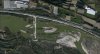
The first one of the attached jpg files sumarizes my problem.
With FSX KML I tried the tag "Legacy_LandWaterMask_Water_NoFlatten" in order to exclude FS native land parts from my river kml's (Photo scenery from FSET, with tag "WaterTwo").
Worked fine, except that some shorelines or banks (?) are still bleeding through.
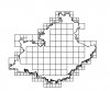
Tried a good many of tags on a large (whole region) exclusion kml, does'nt work! I can get the shp, inf, xml, run*.bat files and even the bgl (second jpg from TmfViewer), but bleedingthrough is still present in FSX.
I have no further idea about a way to manage it, so help would be highly appreciated.
Thanks
JpP
The first one of the attached jpg files sumarizes my problem.
With FSX KML I tried the tag "Legacy_LandWaterMask_Water_NoFlatten" in order to exclude FS native land parts from my river kml's (Photo scenery from FSET, with tag "WaterTwo").
Worked fine, except that some shorelines or banks (?) are still bleeding through.
Tried a good many of tags on a large (whole region) exclusion kml, does'nt work! I can get the shp, inf, xml, run*.bat files and even the bgl (second jpg from TmfViewer), but bleedingthrough is still present in FSX.
I have no further idea about a way to manage it, so help would be highly appreciated.
Thanks
JpP