Firstly hello everyone!I am a first time scenery designer and currently starting the process of creating luton airport ")
Im modeling in gmax as i have found it quite easy to use once u know how, i have just looked throught lots of threads in the past 10 hours on here (u do have a vast ammount of info) but could not find a solution to my problem
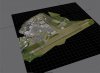
basically im just trying to get the satellite image to show in fs2004 at the moment.(image included) the way i have designed it is 4 rectngles in gmax each having a 1024bmp on it, put together to form the base image. i export it as a an scenery mdl to a destination and use bglcomp to make the bgl... the coordinate im using are "n51 52.64 w0 22.09" which i think is correct but no avail as the sat still could not be seen, i have tried the same technique whith a simple cylinder and yet still see no object, very frustrating!
im sure theres a step i have missed or somthing ive overlooked, not hard when its all new to you im sure u will agree, your help is much appreciated
Im modeling in gmax as i have found it quite easy to use once u know how, i have just looked throught lots of threads in the past 10 hours on here (u do have a vast ammount of info) but could not find a solution to my problem
basically im just trying to get the satellite image to show in fs2004 at the moment.(image included) the way i have designed it is 4 rectngles in gmax each having a 1024bmp on it, put together to form the base image. i export it as a an scenery mdl to a destination and use bglcomp to make the bgl... the coordinate im using are "n51 52.64 w0 22.09" which i think is correct but no avail as the sat still could not be seen, i have tried the same technique whith a simple cylinder and yet still see no object, very frustrating!
im sure theres a step i have missed or somthing ive overlooked, not hard when its all new to you im sure u will agree, your help is much appreciated