• Which the release of FS2020 we see an explosition of activity on the forun and of course we are very happy to see this. But having all questions about FS2020 in one forum becomes a bit messy. So therefore we would like to ask you all to use the following guidelines when posting your questions:

    • Tag FS2020 specific questions with the MSFS2020 tag.
    • Questions about making 3D assets can be posted in the 3D asset design forum. Either post them in the subforum of the modelling tool you use or in the general forum if they are general.
    • Questions about aircraft design can be posted in the Aircraft design forum
    • Questions about airport design can be posted in the FS2020 airport design forum. Once airport development tools have been updated for FS2020 you can post tool speciifc questions in the subforums of those tools as well of course.
    • Questions about terrain design can be posted in the FS2020 terrain design forum.
    • Questions about SimConnect can be posted in the SimConnect forum.

    Any other question that is not specific to an aspect of development or tool can be posted in the General chat forum.

    By following these guidelines we make sure that the forums remain easy to read for everybody and also that the right people can find your post to answer it.

Replacing an island

GHD

Messages
12,243
Country
england
The FSX default coastlines are some distance displaced from their actual position so I attempted to exclude the default and create new coastlines.

FSX coastline


New coastline


Both displayed in TmfViewer


Exclusion polygon


Note. All pics are taken with the same reference point in TmfViewer.

The FSX Map view shows only the intersection of the default and the new hydropoly


I have done this successfully with other islands, can anyone tell me why this particular island doesn't work?

PS. Sorry I captured the mouse pointer in the above pics :eek:
 
Messages
7,450
Country
us-illinois
Hi George:

Do you have some LAT/LON coordinates you can share with us so we can also see if there is anything unusual with the area in TMFViewer? :confused:

GaryGB
 

GHD

Messages
12,243
Country
england
Hi Gary,

Thank you for your response.

The position is Lundy Island in the Severn Estuary, lat 51.1643981944731, long -4.6663970833336

Default:


Photo:


As you can see from the aircraft position, there is a significant displacement.
 
Messages
7,450
Country
us-illinois
Hi George:

That area certainly has the potential to be baffling when seen in TMFViewer! :eek:


In the default [FSX install path]\Scenery\0501\scenery\ folder there are (4) files which cover that area:

APX46130.bgl
BRX46130.bgl
cvx4613.bgl
OBX46130.bgl


"Lundy Island" on my system in [FSX install path]\Scenery\0501\scenery\cvx4613.bgl is actually a GPS Hydro Poly; the surrounding water vector ID is as seen in your post above.

attachment.php


In the UTX Europe [FSX install path]\Scenery\UtExcl\Scenery\ folder there are (8) files which cover that area:
BRU4613E.BGL
HLU4613E.bgl
HPU4613E.bgl
PKU4613E.bgl
RDU4613E.bgl
RRU4613E.bgl
RTU4613E.bgl
STU4613E.bgl


However, 
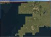
UTX Europe is not successful in "Excluding" it either ...as seen in FSX: ;)

attachment.php


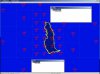
The UTX Europe "Exclude" seen in TMFViewer shows the ineffective [FSX install path]\Scenery\UtExcl\Scenery\HPU4613E.bgl ..."Exclude" GUID:

attachment.php


BTW: The {956A42AD-EC8A-41BE-B7CB-C68B5FF1727E} GUID for the [FSX install path]\Scenery\UtExcl\Scenery\HPU4613E.bgl ..."Exclude" above is found in the FSX SDK "Terrain and Scenery" document as "WaterPolys", but NOT in my FSX Terrain.cfg, which is the modified "Richard Ludowise / Luis Feliz-Tirado Terrain.cfg Fix"; does this result in the UTX Europe "Exclude" poly defaulting to the "regional" land class as seen in the FSX screenie above?


file:///C:/Program%20Files/Microsoft%20Games/Microsoft%20Flight%20Simulator%20X%20SDK/SDK/Environment%20Kit/Terrain%20SDK/Terrain%20and%20Scenery.html


In this thread Dick identifies a purported GUID to Exclude a "WaterPolyGPS":

"{EA0C44F7-01DE-4D10-97EB-FB5510EB7B72} is supposed to be the GUID to exclude for a GPS Water POLY"

http://www.fsdeveloper.com/forum/showthread.php?t=4728


PS: Islands always confuse me... in FSX, after (successfully) excluding water, do we still first "declare land", and then place water polys around the edges of the land as done in FS9 ? :confused:

It seems the FS9 world was a sphere of water covered with islands of land; IIUC, FSX is now a sphere of land... covered with "islands" of water with various texture "classes" ? :rolleyes:


FYI: The SDK states there is a "clipLevel" of QMID-11; does this mean we need to intercept all the other LOD-size tiles around Lundy Island with an exclude to solve this? :

<metadata xml:lang="en">

<FlightSim>
<Geometry clipLevel="11"/>

<AttributeSet>

<AttributeBlock name="WaterPolysGPS" guid="{EA0C44F7-01DE-4D10-97EB-FB5510EB7B72}">
<Field name="Uuid" type="GUID"/>
</AttributeBlock>
</AttributeSet>
</FlightSim>
</metadata>

file:///C:/Program%20Files/Microsoft%20Games/Microsoft%20Flight%20Simulator%20X%20SDK/SDK/Environment%20Kit/Terrain%20SDK/Vector%20Examples/Example1/SourceData/HGX7824.xml

file:///C:/Program%20Files/Microsoft%20Games/Microsoft%20Flight%20Simulator%20X%20SDK/SDK/Environment%20Kit/Terrain%20SDK/Terrain%20and%20Scenery.html


Perhaps this is a "partial" explanation...

http://www.fsdeveloper.com/forum/showthread.php?t=3976


Hope this helps, George, and here's hoping too that Dick and/or others might comment further to clarify ! :)

GaryGB
 

Attachments

  • Lundy_FSX_Top-Down_View_UTXEurope_Active.jpg
    Lundy_FSX_Top-Down_View_UTXEurope_Active.jpg
    98.1 KB · Views: 2,068
  • Lundy_TMFViewer_UTExcl_HPU4613E_No_LOD_Overlay.jpg
    Lundy_TMFViewer_UTExcl_HPU4613E_No_LOD_Overlay.jpg
    59 KB · Views: 1,814
  • Lundy_TMFViewer_Default_cvx4613_No_LOD_Overlay.jpg
    Lundy_TMFViewer_Default_cvx4613_No_LOD_Overlay.jpg
    82.1 KB · Views: 1,706
Last edited:

GHD

Messages
12,243
Country
england
Gary,

I have excluded all objects in the QMid 11 rectangles either side of the island then placed full hydropolys in all except that including the island. In this rectangle I have a hydropoly with a hole in it for the land.

Two exclusions with water polys behind:


Two full hydro polys:


Exclusions removed:


What the default has and I don't is a GPS water poly "covering" the island:


Perhaps this is the problem. However, note that there isn't a GPS water poly in the SE corner :confused:
 

GHD

Messages
12,243
Country
england
I have also done Malta and this almost works. The Map view shows my coastlines for Malta and Gozo but it doesn't show the small island of Comino (between the larger islands). :confused:

Default:


Mine:


Map:


Edit. In this instance there are no GPS water polys in the default file.
 
Last edited:
Messages
7,450
Country
us-illinois
Hi George:

You do nicely detailed work! ;)

Hopefully we'll get to the bottom of this with some further exploration, and perhaps as well, with helpful input by others ...some time soon. :)


GaryGB
 

rhumbaflappy

Administrator
Staff member
Resource contributor
Messages
5,947
Country
us-wisconsin
Hi all.

http://www.fsdeveloper.com/forum/showthread.php?t=4728

Reading that link all the way through, Doug Matthews explains "At FSX, the GPS subsystem has no exception processing logic."

You cannot delete any vectors from a GPS or Map in FSX. It is a limitation of the system. The map will read all water polys and add them together... whether we exclude them or not from the scenery.

FS9 also had problems with the map. I think it could not alter the map at all...and I think the use of areafills crashed the sim.

In order to solve that problem, you'd have to make a replacement for the original cvx file... that that is exactly what we were trying to avoid with FSX.

I still don't understand the use of WaterPolyGPS.

Dick
 

GHD

Messages
12,243
Country
england
WaterPolyGPS are low resolution water bodies used by the GPS display. Intended to keep the GPS subsystem from choking on way too much high res water when zoomed out.

-Doug

Yes, but it doesn't explain why they cannot be removed with an exclusion polygon.
 
Top