Hi Dick:
Now back at a "
Real Computer", I have performed an initial test in SBuilderX with the files in
AddMap.zip attached to your post above:
") http://www.fsdeveloper.com/forum/showpost.php?p=628185&postcount=18
In SBuilderX
http://www.fsdeveloper.com/forum/showpost.php?p=628185&postcount=18
In SBuilderX:
1.) I 'created a New Project' via:
SBuilderX Menu > File > New Project > General Tab > ex: "C-59_AddMap_Test"
2.) I attempted to 'Import' your "
Image1.SBX" file via:
SBuilderX Menu > File > Import > Browse to my local [download path]\AddMap\ > Select "Image1.SBX" > click "Open" button
CAVEAT: "
Import" SBX is
NOT to be confused with the "
Append" SBX process
<
SBuilderX reported an error 'on-screen' >
2.) I exited SBuilderX, then edited my
local [download path]\AddMap\"Image1.SBX":
A.)
BGLProjectFolder=C:\Program Files (x86)\SBuilderX313\Scenery
...was changed to:
B.)
my local path
D:\SBuilderX313\Scenery
Thus, after editing, it reads:
BGLProjectFolder=D:\SBuilderX313\Scenery
Again, In SBuilderX:
1.) I "Imported" your
Image1.SBX file via:
SBuilderX Menu > File > Import > Browse to my local [download path]\AddMap\ > Select "Image1.SBX" > click "Open" button
<
Image1.bmp was successfully imported to SBuilderX and displayed as a background map >
2.) I "Selected your <
"Image1.bmp" background map for processing via:
SBuilderX Menu > Select > All Maps (
< green selection rectangle surrounds image Map >
3.) I attempted to compile a FSX CVX photo-real imagery BGL from the "Selected" Background Map:
SBuilderX Menu > File > BGL Compile > Photo Scenery
A.)
Optional: Start FSX and/or Copy BGL to [SBuilderX install path]\Scenery sub-folder
B.)
Required: Click "
Compile" button (
CMD Resample task runs in a pop-up window, then exits)
NOTE:
No errors were reported by SBuilderX during that process
4.) I inspected the following folders, expecting to find the following pertinent example output files:
A.)
[SBuilderX install path]\Scenery\ sub-folder: '
copy' of "
Photo01.bgl"
B.)
[SBuilderX install path]\Tools\Work\ sub-folder:
1.)
'Original' "
Photo01.bgl"
2.) '
Original' "
Photo01.inf" used with FSX SDK Resample to generate "
Photo01.bgl" from:
...my
local [download path]\AddMap\Image1.bmp
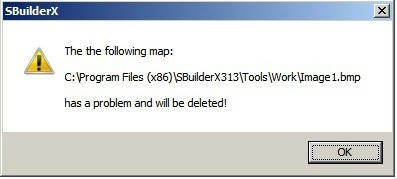
<
SBuilderX incurred an error during processing, but did not report it 'on-screen' >
* '
Original'
[SBuilderX install path]\Tools\Work\Photo01.bgl = MISSING
...and:
* '
Copy' of "
Photo01.bgl" in
[SBuilderX install path]\Scenery\ = MISSING
However, '
Original' "
Photo01.inf" in [SBuilderX install path]\Tools\Work\ = PRESENT
< 'Intended' to be used with FSX SDK Resample to generate "
Photo01.bgl" from:
...my
local [download path]\AddMap\Image1.bmp >
I could not get this process to work in SBuilderX until:
1.) I copied the ...my
local [download path]\AddMap\Image1.bmp file to
create a "working copy" as:
D:\SBuilderX313\Tools\Work\Image1.bmp
2.) I copied the ...my
local [download path]\AddMap\Image1.txt file to
create a "working copy" as:
D:\SBuilderX313\Tools\Work\Image1.txt
3.) Again in SBuilderX, I:
A.) 'Selected' the background Map
B.) 'Compiled' the BGL
4.) Then:
* Inspection of pertinent SBulderX sub-folders showed the original
and copy of the intended output
BGLs were created successfully !
* Inspection of the C-59 Lake Lawn area near the airport showed that ...
creation of the tile of scenery compiled by SBuilderX had been successful !
Thus, it seems that to "Add Map > From Disk", SBuilderX still requires working copies of ones:
* Photo source
*.BMP aerial imagery file(s)
...
and:
* Photo source
*.TXT geo-reference 'world' file(s)
...in ones: [SBuilderX install path]\SBuilderX313\Tools\Work\ sub-folder
What is not yet clear:
1.) Whether SBuilderX automatically converts captured imagery tile(s) in
ex: Google Spherical Mercator
to Geographic Lat / Lon projection / WGS84 datum when one:
A.) Copies Photo source *.BMP aerial imagery file(s)
and Photo source *.TXT geo-reference 'world' file(s) into ones:
[SBuilderX install path]\SBuilderX313\Tools\Work\ sub-folder
B.) Imports a *.SBX (
pre-configured for photo-real scenery creation) ...from
any source folder on disk
C.) Selects the Background Map (
effectively 'Added from Disk') ...when such a SBX is 'Imported')
D.) Compiles the aerial imagery Background Map into a *.BGL
[
EDITED]
NOTE: The process used when tiles are directly downloaded via the 3rd party *.DLL (rather than via Add Map From Disk) ...is discussed here:
http://www.fsdeveloper.com/forum/showpost.php?p=628638&postcount=14
http://www.ptsim.com/index.php?option=com_content&view=article&id=54&Itemid=58
[
END_EDIT]
Dick:
Could you please explain at what point in the above process a
ex: Google Spherical Mercator
to Geographic Lat / Lon projection / WGS84 datum conversion is performed ?
...Or is the conversion instead performed via the 3rd party *.DLL for downloading tiles, prior to when those tiles are written to disk ?
If so, then IIUC, one must still plan to
manually re-project any imagery or other "Map" content intended for use in SBuilderX which were
not downloaded and ' internally' processed via the 3rd party *.DLL for downloading tiles referenced above in this thread.

Thanks again for your consideration in further clarifying the needed workflow in this process.
GaryGB


 >
>