- Messages
- 211
- Country
-

Hi Guys,
I don't know if this kind of tool already existed but... I present you with a tool that allows you to generate a kml file to visualize the geographic boundaries of your .BGL files at the nearest LOD / Qmid And/or BGL Placements of library objects. Rather convenient to view in google Earth and find the BGL corresponding to the area on which we work for example...
many thanks to the useful utility of Patrick Germain: BGLViewer (for debugging and inspirate my BGLFile Class's structure), fsdeveloper wiki on BGL format and Sven2157 for is helpfull FSX library objects web catalog: http://fsxsoc.dynamicfxgroup.com
How to use it:
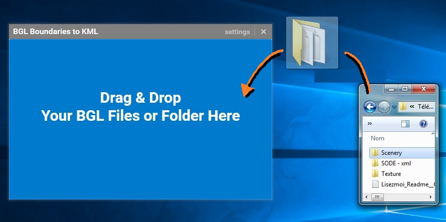
- Works only by "Drag & Drop"! -> Launch the utility and Drag & Drop your BGL files (or the folder) on the tool frame => One or two .KML files will be generated in the folder containing the BGL files.
Polygons of areas covered by the BGL of a scene "Blue Sky" Scenery
What it does:
1 / Generating boundaries as .kml file: BGL_Boundaries.kml
Generates a .kml file of the geographic extent of the areas covered by one or more BGL (s) files. This makes it possible, for example, to view or locate a FSX / P3D Photo Scenery quite easily with google earth and to know which BGL file corresponds to which area.
Supported .BGL file types:
* Field Photo
* Terrain Elevation (Mesh)
* Land Class Land
* Water Class Land
* Land Region
* Season Season
* Density population

Polygons of right of the areas covered by the BGL of a "Blue Sky" Scenery
2 / Generating Placemarks as .kml file : BGL_Placemarks.kml
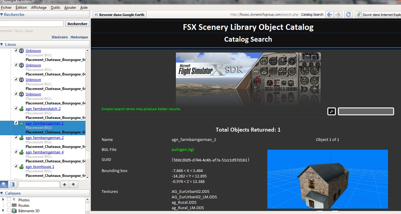
Allows you to generate a .kml file of the .BGL files containing Scenery objects's placements of a Scenery. How it works: If the called Scenery objects and 3D models are declared in the BGL(s) tested, the name of the model and the name of the BGL containing it is automatically associated in the description of the "placemark". Or if the placement refers to an object of the standard FSX library, the software will go directly to http://fsxsoc.dynamicfxgroup.com/to get nformation about the object according to the GUID declared in the BGL (a direct link to the catalog is then added to the placemark's description). The utility will need to access web in order to search for informations, but it's still possible to disable this option in the Settings -> "Get infos from ..." (see image below).
Supported object types:
- for the moment only "Library object".

Placemark object whose 3D model is included in the BGL of the scenery
Placemark object whose 3D model is included in the standard FSX library and therefore referenced on the dynamicfxgroup website


A short video in order to show how the tool work...
I'm sure that some will find a use for that tool...")
Download Here ->BGL Boundaries to Kml
ps: Of course, there may still be bugs, I tested it on only one scene with Terrain Photo and Terrain Elevation data ...
updated 11/13:
- Add FS9 BGL's placement & Library Objects support
Updated 11/09:
- Add Library Object placemarks support
I don't know if this kind of tool already existed but... I present you with a tool that allows you to generate a kml file to visualize the geographic boundaries of your .BGL files at the nearest LOD / Qmid And/or BGL Placements of library objects. Rather convenient to view in google Earth and find the BGL corresponding to the area on which we work for example...
many thanks to the useful utility of Patrick Germain: BGLViewer (for debugging and inspirate my BGLFile Class's structure), fsdeveloper wiki on BGL format and Sven2157 for is helpfull FSX library objects web catalog: http://fsxsoc.dynamicfxgroup.com
How to use it:
- Works only by "Drag & Drop"! -> Launch the utility and Drag & Drop your BGL files (or the folder) on the tool frame => One or two .KML files will be generated in the folder containing the BGL files.
Polygons of areas covered by the BGL of a scene "Blue Sky" Scenery
What it does:
1 / Generating boundaries as .kml file: BGL_Boundaries.kml
Generates a .kml file of the geographic extent of the areas covered by one or more BGL (s) files. This makes it possible, for example, to view or locate a FSX / P3D Photo Scenery quite easily with google earth and to know which BGL file corresponds to which area.
Supported .BGL file types:
* Field Photo
* Terrain Elevation (Mesh)
* Land Class Land
* Water Class Land
* Land Region
* Season Season
* Density population
Polygons of right of the areas covered by the BGL of a "Blue Sky" Scenery
2 / Generating Placemarks as .kml file : BGL_Placemarks.kml
Allows you to generate a .kml file of the .BGL files containing Scenery objects's placements of a Scenery. How it works: If the called Scenery objects and 3D models are declared in the BGL(s) tested, the name of the model and the name of the BGL containing it is automatically associated in the description of the "placemark". Or if the placement refers to an object of the standard FSX library, the software will go directly to http://fsxsoc.dynamicfxgroup.com/
Supported object types:
- for the moment only "Library object".
Placemark object whose 3D model is included in the BGL of the scenery
Placemark object whose 3D model is included in the standard FSX library and therefore referenced on the dynamicfxgroup website
Tool Settings
I'm sure that some will find a use for that tool...
Download Here ->BGL Boundaries to Kml
ps: Of course, there may still be bugs, I tested it on only one scene with Terrain Photo and Terrain Elevation data ...
updated 11/13:
- Add FS9 BGL's placement & Library Objects support
Updated 11/09:
- Add Library Object placemarks support
Last edited:


