• Which the release of FS2020 we see an explosition of activity on the forun and of course we are very happy to see this. But having all questions about FS2020 in one forum becomes a bit messy. So therefore we would like to ask you all to use the following guidelines when posting your questions:

    • Tag FS2020 specific questions with the MSFS2020 tag.
    • Questions about making 3D assets can be posted in the 3D asset design forum. Either post them in the subforum of the modelling tool you use or in the general forum if they are general.
    • Questions about aircraft design can be posted in the Aircraft design forum
    • Questions about airport design can be posted in the FS2020 airport design forum. Once airport development tools have been updated for FS2020 you can post tool speciifc questions in the subforums of those tools as well of course.
    • Questions about terrain design can be posted in the FS2020 terrain design forum.
    • Questions about SimConnect can be posted in the SimConnect forum.

    Any other question that is not specific to an aspect of development or tool can be posted in the General chat forum.

    By following these guidelines we make sure that the forums remain easy to read for everybody and also that the right people can find your post to answer it.

high detail ground poly in 2014:PROBLEM

Messages
39
Country
canada
HI I am learning this process using Bill Womack tutorial,with little luck. Could use some help.
I created my xl spread sheet with the 4 lat and long quadrants. Found the average as explained.
Opened MCX and placed the 2 averages in the default Lat and Long. Opened Coordinate Converter in special tools. The tutorial by Bill Womack and the you tube tutorial by revrengary tell me that my reference points come up automatically. Mine show all 0's I have to manually place everything.
I get 4 digit numbers for my flat earth. x;1897.579 y;1645.099

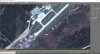
I am proficient in Gmax so the next step was easy. BUT; When I textured my plain with my 24bit BMP it comes out very pixelated. as in pic. Is there something I am doing wrong or is this a setting in Gmax that I need to have set up. MY Gmax is set to 3d using my Gforce 580 drivers.

First off I cand figure why my Coordinate Converter doesn't show the reference points automatically as detailed, and secondly why my textured plain is so pixelated. I used the same image that I used for laying my photo real ground textures over the airport using SbuilderX at LOD17.
Any help here would greatly be appreciated.
Thanks Al
www.flightontario.com
 

Attachments

  • Image problem.jpg
    Image problem.jpg
    440.6 KB · Views: 362
Messages
39
Country
canada
Solved my pizel problem but I would like to know my Coordinate Converter issue
 

tgibson

Resource contributor
Messages
11,343
Country
us-california
Are you using the latest development version of MCX (1.4) or the old stable version (1.3)? Try it with 1.4 if you are using 1.3.
 

jtanabodee

Resource contributor
Messages
3,921
Country
thailand
If you are referring to this tutorial http://www.fsdeveloper.com/wiki/index.php?title=Ground_Poly_Tutorial_for_the_year_2014+,
FYI it is not Bill's tutorial but it is mine. However I used his idea and updated it with new tools and new information.

When you calculate to get the average of coordinate, that will be your (x,y)= 0,0 in Gmax. You need to put these numbers to the options of MCX to be the center of ground poly you are going to make. We do not put this in Gmax or anything like that.

Then the coordinates that are the 4 corners of the image is what you need to put in Coordinate Converter. When you put in, it will give you flat earth X,Y coordinate. Another word, the distance in meters from the center in X, Y. You need select the vertex of each corner and put the right distance number to your corner. Let say, when you put coordinate lat long and it comes up with X=500 Y=300 (or negative value depends on which coordinate you put in.) So your corner on the the upper right hand is X=500, Y=300. Your upper left hand corner is X=-500, Y=300. Your left lower corner is X=-500, Y=-300. And your Right lower corner is X=500, Y=-300.

That's all. When you are done with the reference plane, freeze it to prevent it moving from any fault that you might make in the future.
Hope it helps.
 
Messages
39
Country
canada
I apologize for the mix up. Its a really great tutorial Thanks for taking the time to do it. I got the latest version of MCX and all is good with the world. Got my taxi and parking areas done. Now I just need to find decent asphalt textures. I have been working with taking pics and creating seamless textures. Look ok but not happy yet, I can still see repetitions I'm not happy with. The airport I am doing is CYDF, Deer lake Newfoundland Canada where i lived. The asphalt is all added on over the years so its got several color variations that I am trying to capture.
Thanks again for this help. Really appreciate it.
Al Sibley
 
Top