-
Which the release of FS2020 we see an explosition of activity on the forun and of course we are very happy to see this. But having all questions about FS2020 in one forum becomes a bit messy. So therefore we would like to ask you all to use the following guidelines when posting your questions:
- Tag FS2020 specific questions with the MSFS2020 tag.
- Questions about making 3D assets can be posted in the 3D asset design forum. Either post them in the subforum of the modelling tool you use or in the general forum if they are general.
- Questions about aircraft design can be posted in the Aircraft design forum
- Questions about airport design can be posted in the FS2020 airport design forum. Once airport development tools have been updated for FS2020 you can post tool speciifc questions in the subforums of those tools as well of course.
- Questions about terrain design can be posted in the FS2020 terrain design forum.
- Questions about SimConnect can be posted in the SimConnect forum.
Any other question that is not specific to an aspect of development or tool can be posted in the General chat forum.
By following these guidelines we make sure that the forums remain easy to read for everybody and also that the right people can find your post to answer it.
You are using an out of date browser. It may not display this or other websites correctly.
You should upgrade or use an alternative browser.
You should upgrade or use an alternative browser.
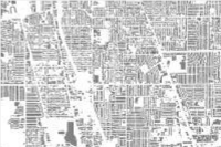
Microsoft released 125 mil building footprints for US
- Thread starter JD Smith
- Start date

MatthiasKNU
Resource contributor
- Messages
- 960
- Country
-

Interesting, I was just about to ask for Building Footprints...
But unfortunately I would need them for Spain and Greece...
Are there already for these countries any Building Footprints, and if not, do you have an idea how do detect them from a simple orthophoto/satellite image, are there pre-defined python-scripts for ArcGIS out there?
EDIT: The 125 million Building Footprints also include various scripts. Can anyone even do something with it and could someone explain to me briefly how to create footprints with these scripts themselves?
Last edited:
- Messages
- 32,885
- Country
-

I don't see any scripts on that Github page, where did you find them?
It seems they used complex AI algorithms with a training dataset to detect the buildings. Will not be something that can be easily done on other area.
I still hope to make scenProc more capable i this area, was working on that for a project in the US. However that might get less priority now this data is available")
It seems they used complex AI algorithms with a training dataset to detect the buildings. Will not be something that can be easily done on other area.
I still hope to make scenProc more capable i this area, was working on that for a project in the US. However that might get less priority now this data is available
MatthiasKNU
Resource contributor
- Messages
- 960
- Country
-
I mean these scripts:
https://github.com/Microsoft/CNTK
And PLEASE: This feature, to detect buildings with Scenproc, would be great!
I tried it already in ArcGis without success, and it would be so important...
https://github.com/Microsoft/CNTK
And PLEASE: This feature, to detect buildings with Scenproc, would be great!
I tried it already in ArcGis without success, and it would be so important...
MatthiasKNU
Resource contributor
- Messages
- 960
- Country
-
Oh, okay, too bad...
I already had the hope that something could have been done with it...
I already had the hope that something could have been done with it...
MatthiasKNU
Resource contributor
- Messages
- 960
- Country
-
Microsoft also released building footprints for Canada:
https://github.com/Microsoft/CanadianBuildingFootprints
https://github.com/Microsoft/CanadianBuildingFootprints
=rk=
Resource contributor
- Messages
- 4,485
- Country
-

ESRI converted the data set into a single layer for distribution.
https://www.arcgis.com/home/item.html?id=f40326b0dea54330ae39584012807126

Hi Bill:
Microsoft's online imagery tile servers "VirtualEarth StreetMap" & "VirtualEarthSatellite" TileServers in SBuilderX ...are BING Maps online.
Also, "ArcGisImagery" TilerServer in SBuilderX ...is what became ESRI ArcGIS "World Imagery" online.
If you wish to use imagery sources not directly downloaded with the SBuilderX TileServer feature, try:
SBuilderX Menu > File > Add Map > From Disk
...if the file is a Geo-rectified *.BMP or GeoTIFF already in the required cartographic projection (Geographic / WGS84).
FYI: There are Satellite imagery Tile Server download utilities in GIS applications such as QGIS, and in ex: FS EarthTiles (aka "FSET").
Specific imagery file formats output from those can also be used in SBuilderX.
GaryGB
Last edited:
- Messages
- 10,088
- Country
-

Man, Gary.. A lot of that went right over the top of my head...
** You wrote;
SBuilderX Menu > File > Add Map > From Disk
## Me; Wouldnt that need to be on my disc?
** You wrote;
...if the file is a Geo-rectified *.BMP or GeoTIFF in already in the required cartographic projection (Geographic / WGS84).
## Me... What? ah whozah whatsits?
** You wrote;
FYI: There are Satellite imagery Tile Server download utilities in GIS applications such as QGIS, and in ex: FS EarthTiles (aka "FSET").
## Me; I think I need to know where this is, if this is freeware imagery. Off to google this and track it down.
** You wrote;
SBuilderX Menu > File > Add Map > From Disk
## Me; Wouldnt that need to be on my disc?
** You wrote;
...if the file is a Geo-rectified *.BMP or GeoTIFF in already in the required cartographic projection (Geographic / WGS84).
## Me... What? ah whozah whatsits?
** You wrote;
FYI: There are Satellite imagery Tile Server download utilities in GIS applications such as QGIS, and in ex: FS EarthTiles (aka "FSET").
## Me; I think I need to know where this is, if this is freeware imagery. Off to google this and track it down.
- Messages
- 10,088
- Country
-
Two simple questions here;
Are ArcGISImagery 'and' (or) Virtual Earth Satellite 'open use'? Can I use these for projects that become payware? If you do not know, that is fine, I can go research it. Hoping you know right off if these are open-ware like Capernicus are.
Capernicus require a subscription for zoom levels over level 5 when downloading their data. (Thats what I read and understood. Perhaps they have a different way of doing things for just getting imagery which might be different then what I am understanding? )
ArcGISImagery is very nice. Good colors. I am very impressed.
https://www.fsdeveloper.com/forum/t...building-footprints-for-us.443109/post-822021
Man, Gary.. A lot of that went right over the top of my head...
** You wrote;
SBuilderX Menu > File > Add Map > From Disk
## Me; Wouldn't that need to be on my disc?
Yes; by default SBuilderX looks for such files first in:
[SBuilderX install path]\Tools\Work
...but IIRC, it can be directed to browse elsewhere for files in the correct GIS projection.
These files can then be manually 'Calibrated' in SBuilderX if they do not already have a matching *.TXT Geo-referencing 'world' file
https://www.fsdeveloper.com/forum/t...building-footprints-for-us.443109/post-822021
** You wrote;
...if the file is a Geo-rectified *.BMP or GeoTIFF in already in the required cartographic projection (Geographic / WGS84).
## Me... What? ah whozah whatsits?
I edited my editing error in the post above from which you quoted that sentence.

FYI: Both SDK Resample for compilation of imagery, and SDK SHP2VEC for compilation of vector source data, require source files to be in a format known as a 'cartographic projection', and which is referred to as Geographic (Lat-Lon) projection / WGS84 geoid or ellipsoid or datum ...aka (EPSG:4326) in GIS applications.
https://www.fsdeveloper.com/forum/t...building-footprints-for-us.443109/post-822021
** You wrote;
FYI: There are Satellite imagery Tile Server download utilities in GIS applications such as QGIS, and in ex: FS EarthTiles (aka "FSET").
## Me; I think I need to know where this is, if this is freeware imagery. Off to google this and track it down.
https://www.fsdeveloper.com/forum/t...building-footprints-for-us.443109/post-822022
Two simple questions here;
Are ArcGISImagery 'and' (or) Virtual Earth Satellite 'open use'? Can I use these for projects that become payware? If you do not know, that is fine, I can go research it. Hoping you know right off if these are open-ware like Capernicus are.
Capernicus require a subscription for zoom levels over level 5 when downloading their data. (Thats what I read and understood. Perhaps they have a different way of doing things for just getting imagery which might be different then what I am understanding? )
ArcGISImagery is very nice. Good colors. I am very impressed.
Some tile servers may offer imagery that is public domain and free to use for freeware and payware projects; most do not.
They are most often intended for use as background images over which custom objects may be created by the end user.
One must personally communicate with the licensor of the imagery that is made accessible via tile servers to determine terms of use, if those terms are not otherwise clearly stated on the website for the tile server web portal.

PS: ArcGISImagery terms of use:
https://goto.arcgis.com/termsofuse/viewtermsofuse
GaryGB
Last edited:
- Messages
- 32,885
- Country
-
Like Gary said most images sources can be used in either freeware or payware products. In general Google, Ms, etc license the images from different suppliers and you are not allowed to redistribute them.
If you are working on the US it might be USGS data is used, which in general can be redistributed. But you need to check the source of the images to be sure.
If you are working on the US it might be USGS data is used, which in general can be redistributed. But you need to check the source of the images to be sure.
- Messages
- 10,088
- Country
-
Like Gary said most images sources can be used in either freeware or payware products. In general Google, Ms, etc license the images from different suppliers and you are not allowed to redistribute them.
If you are working on the US it might be USGS data is used, which in general can be redistributed. But you need to check the source of the images to be sure.
Interesting... Thanks Arno. I did find that the imagery used in Google was Capernicus and I asked Capernicus if it was possible to use their images and they said 'absolutely, except please mention us as the producer of the images'. I obtained them through Google, and they were from Capernicus and Google stated that they are Capernicus images.
I wonder if that is good enough to allow me to use them. Capernicus did give me permission. I do not want to mess up on permissions.