- Messages
- 453
- Country
-

Hi gents,
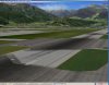
I am totally confused now. I tried for weeks to manage a proper flatten for my project (LOWI). Whatever I am doing I get some weird results:
*I have an aerial photo for the airport. This photo is sliced into tiles with a measure of below 100m each and applied to groundpolys made with the fs2002 gamepack from gmax.
*The flatten command is made with fsX KML - the poly has an altitude of 579m
*The airport itself is located at 579m (checked with both AFX and ADE), same for the reference point.
Everything works ok so far as long as I do not use intersections (taxiways) or surface polygons (tarmac). When I am adding such objects they are significantly above the mentioned 579m and accordingly do not follow the flatten.
What could have been gone wrong?
Any hint is appreciated!
regards
Last edited:


")