• Which the release of FS2020 we see an explosition of activity on the forun and of course we are very happy to see this. But having all questions about FS2020 in one forum becomes a bit messy. So therefore we would like to ask you all to use the following guidelines when posting your questions:

    • Tag FS2020 specific questions with the MSFS2020 tag.
    • Questions about making 3D assets can be posted in the 3D asset design forum. Either post them in the subforum of the modelling tool you use or in the general forum if they are general.
    • Questions about aircraft design can be posted in the Aircraft design forum
    • Questions about airport design can be posted in the FS2020 airport design forum. Once airport development tools have been updated for FS2020 you can post tool speciifc questions in the subforums of those tools as well of course.
    • Questions about terrain design can be posted in the FS2020 terrain design forum.
    • Questions about SimConnect can be posted in the SimConnect forum.

    Any other question that is not specific to an aspect of development or tool can be posted in the General chat forum.

    By following these guidelines we make sure that the forums remain easy to read for everybody and also that the right people can find your post to answer it.

FSX VogelTree, new tool for detecting vegetation like AgenT

Messages
211
Country
france
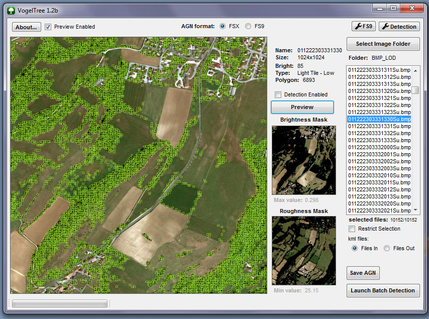
After trying to add a batch mode to AgenT vegetation detection with Macro Agent... Based on the principles of AgenT creator: Lars Hoyer, I've tried to make a new tool that I named very modestly VogelTree :D

!!! based on excellent Arno's DLL !!!

it's an utility dedicated to creation of sparse vegetation on AGN files from images derived from FSearthTile bmp format. The operation is almost identical to "Agent" with a few differences:
- Processing of batch files.
- support "Area_*********" bmp or tga file from FsearthTile and "xxxxxxxxxxx.Su.bmp" from FS2004, !! At that time the Picture must have LOD13 width !!
- support DXT compressed BMP (thx to Arno :) )
- The algorithm can be adapted to 10 profiles based on a personnal "brightness" value of picture.
- A special algorithm (filter 1) * detection of vegetation was coupled with the detection of the brightness function like AgenT(filter 2) .
- Possibility to change the settings of those two algorithms.
- support of FSX and FS9 out. (one more thx to Arno :) ) (with polygon number limitation if needed)

* Algorithm to differentiate plain area (field) of "rough" area (bushes, trees).

capt_vogeltree1.2_pal.jpg


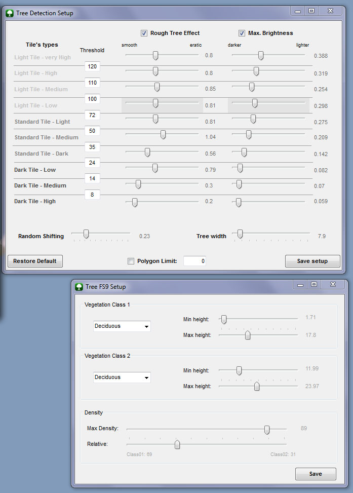
Information about settings :
I arbitrarily defined ten category based on an almost average brightness of the image.
It is possible to set thresholds and transitions between two categories.
For each category it is possible to set both maximum values ​​of the two algorithms.
Filter 1: "Rough", higher is the value, more "scrubby"/"Rough" must be the area to be validated.
Filter 2: "brightness", smaller is the value, darker must be the area to be validated.

capt_vogeltree1.2_pref.jpg


Advice:
- the default parameter of this tool are more adapted to work with picture of 1024x1024 resolution. adjustement are surely needed.
- higher is the resolution, better is the detection, more time by frame is needed.
- It work with 256x256 picture but you need to desactivate the "rouh" filter to work with.


Well so far I have tested the product quickly and it seems to work not too bad ... although it should probably make some adjustments on the detection settings. New algorithm to further refine the detection probably ... Research can continue. test it if you want ...

In fact it is still a beta version so still full of bug and surely many other oversights. Indulgence desired :eek:

the tool: VogelTree 1.4 beta

french post on pilote-virtuel translated
 
Last edited:

arno

Administrator
Staff member
FSDevConf team
Resource contributor
Messages
32,883
Country
netherlands
Hi,

Thanks for the tool, looks interesting.

Like I told you in the pm I have been experimenting with vegetation detection a bit as well recently. My scenery is for fsx, so I don't have texture tiles to feed through your tool though. But the way you describe the algorithm sounds interesting.
 
Messages
211
Country
france
thanks Arno :)

This is the way I generate my Pictures Tiles to work on:

With FS Earth Tile 1.03 : Generate tiles corresponding to the desired area, here are my options:
- Download Resolution: 1 (for the 1024x1024) or 0 (for the 2048 x 2048) or -1 (for the 4096x4096)
- Scen Compiler: FSX
- Area Snap: LOD13
- Creat Masks: No (or Yes)
- Comp Scenery: No (or Yes)
- Use Cache: Yes

- Auto Ref. Mode: 4

20130525152630fsearthti.jpg
 

arno

Administrator
Staff member
FSDevConf team
Resource contributor
Messages
32,883
Country
netherlands
Hi,

What I meant is I only have geotiff files and a resample inf file for my project, I don't work with tools like FS earth tiles or so. I don't think your tool works in geotiff as well :)
 

hcornea

Resource contributor
Messages
2,388
Country
australia
Hmmm ... would be interesting if this could be fed a Geotiff, or similar.
 

RicherSims

Resource contributor
Messages
567
Country
dominica
I must say Vogel: Amazing work!
Looks like I'll be redoing my autogen soon!
 
Last edited:
Messages
211
Country
france
Hi,

What I meant is I only have geotiff files and a resample inf file for my project, I don't work with tools like FS earth tiles or so. I don't think your tool works in geotiff as well :)

you're all right, I will try to implement support of files with width different from LOD13...

Information on algorithm: the "rough" filter is based on something I've found when I watched the Color Histogram of a little "Tree" box compared to a little "field" box with photoshop. The first one have a larger base("eroded mountain", cause of wider range of brightness) compared to the second wich have a smaller base ("sharp moutain", smaller range of brightness).I compare just the range of green color(0->255) between min_value and max_value.
 

ollyau

Resource contributor
Messages
1,026
Country
us-california
Looks impressive!

If you begin to support GeoTIFF, would it be possible to additionally read from a near infrared band to help determine vegetation location? Much of the freely available NAIP imagery has NIR data in the 4th channel.
 
Messages
211
Country
france
@ollyau

first I will try to support GeoTiff ;) I don't know if I can (hard to manage projection)... but infra-red reading seems to be a good idea.
 

arno

Administrator
Staff member
FSDevConf team
Resource contributor
Messages
32,883
Country
netherlands
Hi,

I have been experimenting with GeoTIFF in the past already. So I might be able to help with that. And I would be willing to put similar functionality in scenProc as well. So maybe we can work together on that.
 
Messages
13
Country
germany
Hi Vogel,
I tried to start you programm and it crashed.. I dont see any gui, it just crash.
I tried it on other PCs same problem. Also other language dosn`t work.

I looked in the readme and if I understand it right there is nothing to configure, is that right?

What I am doing wrong?
Hope you could give me a hint :)

Best regards from germany

Sebastian
 
Messages
211
Country
france
Hummmm !? Hi xflash, what is your system (xp,seven)? No error message ? Do you have framework 4 installed ?
 
Last edited:
Messages
13
Country
germany
Oh sorry forgot it.. Win7 32/64 and Windows 2012 Server.. .net 4.0 is installed.

I get only the massage the program has stoped working.. I the event viewer i get this error:

Event 1026 .net Runtime:

Application: VogelTree.exe
Framework Version: v4.0.30319
Description: The process was terminated due to an unhandled exception.
Exception Info: System.ArgumentOutOfRangeException
Stack:
at System.Windows.Forms.TrackBar.set_Value(Int32)
at VogelTree.frm_principal.InitSetup()
at VogelTree.frm_principal.Initialisation()
at VogelTree.frm_principal..ctor()
at VogelTree.Program.Main()

Event 1000 Application Error

Faulting application name: VogelTree.exe, version: 1.0.0.0, time stamp: 0x51a55ea8
Faulting module name: KERNELBASE.dll, version: 6.1.7601.17514, time stamp: 0x4ce7b8f0
Exception code: 0xe0434352
Fault offset: 0x0000b760
Faulting process id: 0xc50
Faulting application start time: 0x01ce5efa7d07ecd2
Faulting application path: Z:\vmshare\VogelTree1.2b\VogelTree.exe
Faulting module path: C:\Windows\system32\KERNELBASE.dll
 
Last edited:
Messages
211
Country
france
thx Sebastian,

May be the problem come when the tool load & parse setup file :confused: So it could be a problem with the "decimal symbol", dot vs comma as Arno speak in SceneryDesign blog last week. First please check if you use "." and not "," as decimal symbol in your regional option... I hope it's only that :cool:
 
Messages
13
Country
germany
Hi Vogel.. That was the problem.
I use an english Windows with german regio setting.. It seemed i forgot it to switch.. :banghead:

Thanks for your help..
 
Messages
211
Country
france
Update of VogelTree: VogelTree 1.3 beta

- Bug of "Area ..... bmp" file management fixed.
- The masks are now represented by only black & white picture.
- Ability to setup the default GUID used to create the FSX AGN ("Detection setup" window)
- Added checkbox's state of "Detection setup" window, the GUID and limit number of polygon into the saved parameters
- The Tile's Type is being henceforth also highlighted when pressing "preview"

! Sorry but not support of Geotiff yet !

Please note:
to adjust more accurately the various sliders:
- Left-click on the cursor set, then use the left and right arrow keys to increase or decrease its value accurately.
 
Last edited:
Messages
111
Country
austria
Maybe you are aware of but you should take a look on this website: http://www.ecognition.com/

I played around a bit with the developer (trial) version in the past, it's a great tool for geospatial analysis. It's even possible to differ treetypes from (high resolution) aerial image analysis.

A very mighty and expensive tool though but maybe you could learn from the algorythms.

Regards,
Heinrich
 
Top