• Which the release of FS2020 we see an explosition of activity on the forun and of course we are very happy to see this. But having all questions about FS2020 in one forum becomes a bit messy. So therefore we would like to ask you all to use the following guidelines when posting your questions:

    • Tag FS2020 specific questions with the MSFS2020 tag.
    • Questions about making 3D assets can be posted in the 3D asset design forum. Either post them in the subforum of the modelling tool you use or in the general forum if they are general.
    • Questions about aircraft design can be posted in the Aircraft design forum
    • Questions about airport design can be posted in the FS2020 airport design forum. Once airport development tools have been updated for FS2020 you can post tool speciifc questions in the subforums of those tools as well of course.
    • Questions about terrain design can be posted in the FS2020 terrain design forum.
    • Questions about SimConnect can be posted in the SimConnect forum.

    Any other question that is not specific to an aspect of development or tool can be posted in the General chat forum.

    By following these guidelines we make sure that the forums remain easy to read for everybody and also that the right people can find your post to answer it.

default sceneries in FSX

Messages
2,192
Country
germany
Hello,

my PC is not "up to FSX" yet.
In order to cope I try all possible means to improve framerate and to reduce loading times.

For the latter I activate only the bare - for each flight required - minimum of sceneries and addons.

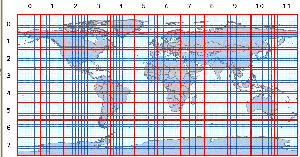
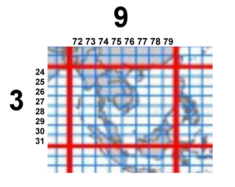
In this context I am interested, which of the "standard sceneries" in FSX are related to which area. The familiar entries like "EurE" or "NamW" of course pose no problem.

But all those sceneries from "0000" to "1107" do pose a problem, in particular since some of them seem to be "mandatory"

After this lengthy intro here is my short question:
Is there a list available, which relates the obscure scenery numbers to real areas?

Some insight would be highly appreciated.

sincerely

Helli
 
Each Dir/file number is filled with many airports for a specific area. I am not sure removing any of these numbers is going to lower FPS because if you are not in that part of the world the scenery does not load.

If you have the FSX delux version, MS gave us a utility in the SDK called a TMFviewer. This allows us to look at the FSX world and once the correct bgl is loaded into the utility the mouse pointer will identify the DIR and the bgl file number.

You can also use other means to single out one airport such as. If you have FS9 and the AFCAD program that will tell you what file number (not DIR) a airport is nesting in at the FSX folders.

Another way is to use FSXPlanner which uses a process to find a airport in the DIR/file number.

I am sure there might be other Utilities available but I have never seen a list made up yet to identify 24000+ airports and what DIR/File they are all in.
 
Hello Jim!

thanks for your answer!!

65 readings and only 1 answer - that does not make this topic too popular - or is it to the majority as obscure as to me?

Well, you point out 3 methods.
But for me they kind of "look in the wrong direction".

My interest is not, which bgl's belong to the scenery in which I am presently.
I am interested, to which area of the world belong the bgl's say in the directory with the nondescriptive name "1107".

I will look closer to "TMFviewer" and experiment a little bit. May be that provides some kind of explanation to my question.

Your help - as always given in such a friendly way by you - is highly appreciated

by

Helli
 
Hello Lance!

Thanks a lot for your clarification.
This is indeed exactly the answer, which I have been seeking.

I dare to copy here this "grid" and the related text from the SDK - and I hope, that the admin does not mind.
It should provide the proper answer to anybody, who is interested in this thread
Here we go:

Copy from "Terrain and Scenery.html"
----------------------------------------------------------------------------------
Base File Information

The file system used to store all the terrain information is based around the following grid. In Microsoft Flight Simulator X\Scenery you will notice many folders with numeric names such as 0000, 1107, and so on. The first two numbers refer to the column of data (from 00 to 11) and the second two to the row of data (from 00 to 07). So 0000 contains the default information for the top left hand rectangle in the diagram below, and 1107 the information for the bottom right hand rectangle.

BaseGrid.bmp

Figure: Base-Grid (from "terrain and scenery.html")

This is a different grid system than the 1.2Km squares used previously. This system is used to organize the data files in a reasonably logical way. The large grid squares represent QMID level 4, the smaller squares QMID level 7 (see QMID and LOD values for more details).

Each of the larger rectangles (shown in red) is divided into smaller rectangles (shown in blue).
There are 8 x 8 smaller rectangles within each larger one.
These smaller rectangles reference scenery and vector data that is present within that area. These are also numbered column first, then row, so the small grid square 7824, for example, is the area around Hong Kong SAR (which falls in the large grid square 0903).
Clarification by Helli:
The number of a "small square" is derived by multplying the "large square" line and column number by 8

BaseGridklein.bmp


If you take, for example, the folder 0303, this will contain data for much of the Caribbean Sea. Use TmfViewer to open the dem0303.bgl file in this folder, and you will see the following high resolution elevation data image. Each of the numbered directories will contain elevation data with demNNNN in the filename. This higher resolution data is used to draw the landscape more accurately when using Flight Simulator X when compared with the previous version, Flight Simulator 2004. See the Elevations section for a comparison of lower and higher resolution images of Hawaii.
------------------------------------------------------------------------

This concludes this thread very nicely, thanks to Jim and in particular Lance, the help of whom I appreciate very much.

sincerely yours

Helli
 
Last edited:
Back
Top