• Which the release of FS2020 we see an explosition of activity on the forun and of course we are very happy to see this. But having all questions about FS2020 in one forum becomes a bit messy. So therefore we would like to ask you all to use the following guidelines when posting your questions:

    • Tag FS2020 specific questions with the MSFS2020 tag.
    • Questions about making 3D assets can be posted in the 3D asset design forum. Either post them in the subforum of the modelling tool you use or in the general forum if they are general.
    • Questions about aircraft design can be posted in the Aircraft design forum
    • Questions about airport design can be posted in the FS2020 airport design forum. Once airport development tools have been updated for FS2020 you can post tool speciifc questions in the subforums of those tools as well of course.
    • Questions about terrain design can be posted in the FS2020 terrain design forum.
    • Questions about SimConnect can be posted in the SimConnect forum.

    Any other question that is not specific to an aspect of development or tool can be posted in the General chat forum.

    By following these guidelines we make sure that the forums remain easy to read for everybody and also that the right people can find your post to answer it.

Photoscenery texture problem

Messages
82
Country
israel
Hi, I'm pretty new here and for the business of scenery design.
so straight to my problem, I've been working on Tashkent photoscenery and run to some problem with the layering.
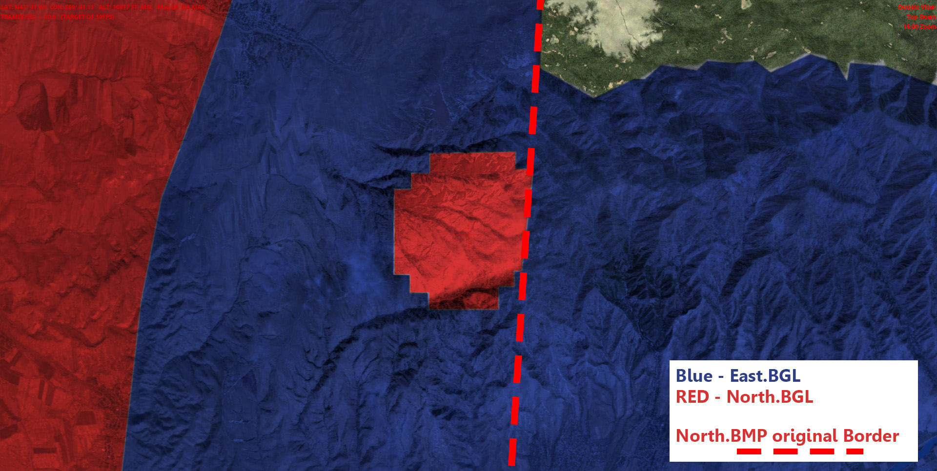
I have some conflict with two BGL files, The layer that under the top BGL pops up on the top layer, nevertheless tow of this layers have a blendmask
Untitled-1.jpg


Untitled-2.jpg


Untitled-3.jpg


I tried everything but I cant find the answer
I use Sbuilder and sampler

here are the INF frome the tow files
EAST BGL:
________________________________________________________
[Source]
Type = MultiSource
NumberOfSources = 3

[Source1]
Type = BMP
Layer = Imagery
SourceDir = "."
SourceFile = "L14X22695X22772Y12196Y12299E2.BMP"
Variation = March, April, May, June, July, August, September,October, November,
Channel_BlendMask = 3.0
NullValue = 255,255,255
SamplingMethod = Gaussian
ulyMap = 41.7385284693592
ulxMap = 69.334716796875
xDim = 4.29153442382827E-05
yDim = 3.22353389359563E-05

[Source2]
Type = BMP
Layer = Imagery
SourceDir = "."
SourceFile = "L14X22695X22772Y12196Y12299E2_winter.BMP"
Variation = December, January, February
Channel_BlendMask = 3.0
NullValue = 255,255,255
SamplingMethod = Gaussian
ulyMap = 41.7385284693592
ulxMap = 69.334716796875
xDim = 4.29153442382827E-05
yDim = 3.22353389359563E-05

[Source3]
Type = BMP
Layer = None
SourceDir = "."
SourceFile = "L14X22695X22772Y12196Y12299E2M.bmp"
SamplingMethod = Gaussian
ulyMap = 41.7385284693592
ulxMap = 69.334716796875
xDim = 4.29153442382827E-05
yDim = 3.22353389359563E-05


[Destination]
DestDir = "."
DestBaseFileName = "Photo01"
DestFileType = BGL
LOD = Auto
UseSourceDimensions = 1
CompressionQuality = 85

________________________________________________________

and NORTH BGL

[Source]
Type = MultiSource
NumberOfSources = 3

[Source1]
Type = BMP
Layer = Imagery
SourceDir = "."
SourceFile = "Tashkent_X_North.BMP"
Variation = March, April, May, June, July, August, September,October, November,
NullValue = 0,0,0
SamplingMethod = Gaussian
Channel_BlendMask = 3.0
ulyMap = 41.9594900989247
ulxMap = 68.62060546875
xDim = 4.29153442382807E-05
yDim = 3.20699968830372E-05

[Source2]
Type = BMP
Layer = Imagery
SourceDir = "."
SourceFile = "Tashkent_X_North_winter.BMP"
Variation = December, January, February
NullValue = 0,0,0
SamplingMethod = Gaussian
Channel_BlendMask = 3.0
ulyMap = 41.9594900989247
ulxMap = 68.62060546875
xDim = 4.29153442382807E-05
yDim = 3.20699968830372E-05

[Source3]
Type = BMP
Layer = None
SourceDir = "."
SourceFile = "Tashkent_X_North_Blendmask_L.BMP"
SamplingMethod = Gaussian
ulyMap = 41.9594900989247
ulxMap = 68.62060546875
xDim = 4.29153442382807E-05
yDim = 3.20699968830372E-05

[Destination]
DestDir = "."
DestBaseFileName = "Photo01"
DestFileType = BGL
LOD = Auto
UseSourceDimensions = 1
CompressionQuality = 85
___________________________________________________

other question
If there is any way to separate one BGL into a grid of BGL's?
 
Hello:

The area of the rectangle with clipped corners seen directly under the user aircraft is within the "visual display radius" which will show higher LOD imagery and/or terrain mesh and/or vector data.

In this case, the bottom Red layer BGL likely contains higher LOD aerial imagery than the top Blue layer BGL.


Please examine your Blue and Red FS SDK Resample output BGLs in FS SDK TMFViewer:

[FSX SDK install path]\Environment Kit\Terrain SDK\TmfViewer.exe


When loaded into TMFViewer, one can see what LOD's are in the BGLs output by FSX SDK Resample due to INF "LOD=[number]" parameter values:

TMFViewer Menu > View > Level Of Detail

[EDITED]

The FS run time rendering engine will preferentially display the layer with a higher number LOD on top of other layers regardless of their location in the FS scenery library GUI stack of layers.

[END_EDIT]


In the INF for the Blue layer, use LOD=Auto,13 (or any number greater than 13 so that it is a higher LOD=[number] than that of the RED layer INF)


Let us know if you have any further questions on this process. :)

GaryGB
 
Last edited:
Hi GaryGB, thank you for the reply
I find out that the BLUE BGL is lod14 and the RED also 14
so I edited the RED inf file to "LOD=Auto,13"
after placing the new bgl file into the scenery it doesn't appear and instead I sea the default FS ground
what do I do wrong now?
and could resizing the source BMPs by50% will help?

[Source]
Type = MultiSource
NumberOfSources = 3

[Source1]
Type = BMP
Layer = Imagery
SourceDir = "."
SourceFile = "Tashkent_X_North.BMP"
Variation = March, April, May, June, July, August, September,October, November,
NullValue = 0,0,0
SamplingMethod = Gaussian
Channel_BlendMask = 3.0
ulyMap = 41.9594900989247
ulxMap = 68.62060546875
xDim = 4.29153442382807E-05
yDim = 3.20699968830372E-05

[Source2]
Type = BMP
Layer = Imagery
SourceDir = "."
SourceFile = "Tashkent_X_North_winter.BMP"
Variation = December, January, February
NullValue = 0,0,0
SamplingMethod = Gaussian
Channel_BlendMask = 3.0
ulyMap = 41.9594900989247
ulxMap = 68.62060546875
xDim = 4.29153442382807E-05
yDim = 3.20699968830372E-05

[Source3]
Type = BMP
Layer = None
SourceDir = "."
SourceFile = "Tashkent_X_North_Blendmask_L.BMP"
SamplingMethod = Gaussian
ulyMap = 41.9594900989247
ulxMap = 68.62060546875
xDim = 4.29153442382807E-05
yDim = 3.20699968830372E-05

[Destination]
DestDir = "."
DestBaseFileName = "Photo01"
DestFileType = BGL
LOD = Auto,13
UseSourceDimensions = 1
CompressionQuality = 85
 
Last edited:
Hi GaryGB, thank you for the reply

I found out that the BLUE BGL is LOD-14, and the RED is also LOD-14.

So I edited the RED inf file to "LOD=Auto,13".

After placing the new bgl file into the scenery it doesn't appear, and instead I see the default FS ground; what did I do wrong now?

Hi Felix:

Since the BGL's for both the red and blue layers were originally able to be output from the provided source imagery by FS SDK Resample at LOD-14, then more likely the problem is that the blend mask for the Blue layer is allowing the Red layer to show through to the top.

Try adjusting the blend mask 'transparency' between the top Blue layer and the underlying Red layer.

By changing the grayscale "color" of the blend mask in the 8-bit Alpha channel of the image used for the Blue layer, you can determine how much, if any, of the underlying Red layer is allowed to show through to the top of the Blue layer.

Also, try adjusting the blend mask 'transparency' between the underlying Red layer and the (even lower) underlying default land class layer.

By changing the grayscale "color" of the blend mask in the 8-bit Alpha channel of the image used for the Red layer, you can determine how much, if any, of the underlying default land class layer is allowed to show through to the top of the Red and/or Blue layer.

And would re-sizing the source BMPs by 50% help?

No, IMHO, do not re-size the source BMP files; if you changed their size, their aspect ratio and Geo-referencing would change (not a good thing !) ;)


PS: What graphics application are you using to create / edit the BMP files and their associated Alpha channels ? :scratchch


Hope this helps sort things out with your layering and masking ! :)

GaryGB
 
Last edited:
Hi again, I think I mange to fix it
I set "Lod = auto,14" to the blue layer and the problem gone
now I have one more bgl to fix
so thank you for your help

now I still looking for the answer if I can divide big BGL into smaller part?
 
Hi Felix:

Congratulations ! :)

Now I have one more bgl to fix.

So thank you for your help

Now I am still looking for the answer if I can divide big BGL into smaller part?

Please explain further what you mean by "divide (a) big BGL into (multiple) smaller part(s)" ? :confused:

Are you having an issue with SBuilderX running out of memory during a tile downloading and/or FSX SDK Resample compiling task session ?

Or are you instead concerned about the resulting BGL size otherwise successfully output by FSX SDK Resample ? :scratchch

GaryGB
 
Hi again GaryGB, Well, probably it a stupid question, as i said, Im pretty new to scenery design for FS so i don't know how everything work so maybe its impossible but still....:oops:
My BLG files are very big 200-400Mb and I interested in uploading and sharing them, is there a way to separate each file into smaller parts?
Is there any command in the sampler that can export the file in parts instead of one big file? so I can pack them and share them.
I hope my question is clear now

thank you again :)
 
Hi Felix:

If you are concerned about maintaining smaller BGL sizes because your upload options for a free download site restricts you to submission of files that are no bigger than for example 200 MB in size, then certainly you can divide the output files generated by FS SDK Resample into several smaller BGLs.

But, just so that you know, FSX has no problem working with aerial imagery and or terrain mesh FSX SDK Resample compiled BGL output files that are up to 2 GB in size. ;)

IIUC, there may actually be a performance detriment to implementing one's aerial imagery data in separate BGLs: :idea:

http://msdn.microsoft.com/en-us/library/cc707102.aspx#PerformanceTipsforAerialImagery


FYI
: Entire aerial imagery and or terrain mesh BGL files are not actually loaded into memory, but instead 'pointers' are created and loaded for different hexadecimal code regions of the BGL file, and FS terrain data pre-loading threads for the run time rendering engine retrieve / load only what is needed to render locally within the visual display LOD radius based on the present Geographic coordinates of the user aircraft.

Because you are working with aerial imagery BGL files that are already compressed nearly to the maximum size possible, I can understand your concern that you would not be able to further compress any such BGL's larger than 200 MB so that they would fit into the file size that uploaded files are restricted to on some free download sites.

However, there is an alternate solution for this. :idea:

By using a freeware utility for file compression such as 7Zip or the freeware /nag-ware version of WinRAR, one can segment a single file into multiple pieces by an assigned maximum file size target, such as 200 MB per segment, all of which can then be uploaded to your free download site because they meet the legal size restriction requirements of that web site.

http://www.7-zip.org/

http://www.rarlab.com/download.htm


Then the end user can download all the segments which make up the scenery package, and reassemble those pieces into a 1-piece file using 7Zip or WinRAR on their own computer. :pushpin:

Feel free to further explain what any ongoing concern may be, and I'll be glad to try and offer some further clarification and/or ideas. :)

GaryGB
 
Last edited:
Back
Top