• Which the release of FS2020 we see an explosition of activity on the forun and of course we are very happy to see this. But having all questions about FS2020 in one forum becomes a bit messy. So therefore we would like to ask you all to use the following guidelines when posting your questions:

    • Tag FS2020 specific questions with the MSFS2020 tag.
    • Questions about making 3D assets can be posted in the 3D asset design forum. Either post them in the subforum of the modelling tool you use or in the general forum if they are general.
    • Questions about aircraft design can be posted in the Aircraft design forum
    • Questions about airport design can be posted in the FS2020 airport design forum. Once airport development tools have been updated for FS2020 you can post tool speciifc questions in the subforums of those tools as well of course.
    • Questions about terrain design can be posted in the FS2020 terrain design forum.
    • Questions about SimConnect can be posted in the SimConnect forum.

    Any other question that is not specific to an aspect of development or tool can be posted in the General chat forum.

    By following these guidelines we make sure that the forums remain easy to read for everybody and also that the right people can find your post to answer it.

Beta coming for Northern Utah and GA's (Enhanced PR)

Messages
204
Country
us-texas
We are preparing for the Beta release of the following product for Northern Utah. We are not doing KSLC, since Pacsim did that one, and our interest is more in GA anyhow.

The product will include 3 GA airports and about half the entire state of Utah for PR coverage. We spent an insane amount of time color correcting the state, it will be very close to REAL color (and we mean it) with a touch of color POP added. The included Airports are Heber City, Logan, and 1 unannounced. Hopeful release date is March to April of this year. Most of the work is finished, but we have 1 airport left and some Autogen work left.

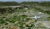
Just East of Salt Lake City (towards Heber and south of Park City)
Mtns1.png
Utah2.png

High Mountain Valley after melted snow
Utah2.jpg

Wet Hangar Door from Rain (just for fun)
Utah4.jpg
 

Attachments

  • Utah3.jpg
    Utah3.jpg
    490.9 KB · Views: 518
Last edited:
Looks very nice! Just some questions: will your photoscenery be color corrected to blend nicely with the Pacsim region. Pacsim seem to have winter texture as well as summer in their scenery area, will your scenery also have winter textures? If not I guess it will look a bit strange flying from Pacsim Salt Lake City in white winter to your area with all green textures in summer fall and spring? Will your scenery have full autogen? Are you using 1 m/pixel or 50 cm?

Again, it looks great and look very much forward to it, freeware or payware?

Mike
 
We have some custom trees, so you will get custom Autogen for trees and full ScenProc FSX-autogen for the buildings. We will continually expand our library as we go.
 
Last edited:
Payware is the way to go, I agree. It shows you have put time in to this so very justified. Where I disagree a bit is regarding the combination with pacsim. Rather than you color correct it to blend with their scenery and include winter textures with yours you instead mean I should deactivate their perfect 50 cm textures with full winter textures and outstanding hand placed autogen and all this for a very large area they include and instead use your textures that are not winter and from what I understand less autogen detailed. Just speaking for myself here :) I would rather pay you a little higher price for a winter season and a good blend with their summer and winter textures than the other way around to be honest. Or at least color corrected in the corners where your scenery meet theirs for a somewhat smooth blend.

This is just me opinion here but to go the same route as everyone else (Megascenery, UltimateVFR and the free Bluesky) with only one season really in my very huble opinion does not really justify a purchase, at least not for me no matter how color corrected it is. Like Steve Jobs once said "you need to find a very good reason for the products to be, to exist".

In addition Pacsim even use their own autogen buildings, would hate to loose that as well.

With over 20 years with this hobby and having seen and used all sorts of addon over the years I would be happy to help out if you need someone to test.

Mike
 
Last edited:
A lot of Pacsim's best work are the custom buildings. So the custom buildings still show up (which is their unique stuff), and our autogen includes custom trees + buildings. I think Pacsim did a pretty good job on their buildings and downtown SLC-Utah, but our PR adds an entirely different level to it.

Thanks for the comments, but this looks nothing like MSE, UVFR, or Bluesky. I could have compiled the entire US by now and given it away free if I wanted, but why release more low quality PR.

Not only just color corrected, we completely break down and clean up as much noise in the image as possible and then re-sharpen, then we use over 5000 custom lines of code interacting with ImageMagick.
 
Last edited:
Here is a BETTER comparison of typical 1m vs what I did...

Both these split shots come from the same NAIP source.... The left is what the imagery would have looked like before I ran it through the processing...

The visual interpretation of resolution is only PARTLY resolution, the reason we see the NAIP as low resolution is because of a function of missing contrast, noise, missing shadows, and missing sharpness. Once it is re-balanced and added back, the perceptual resolution increases greatly.

As noted, this probably looks nothing like the 1m you've seen before... There are no tricks here, these are unedited results I captured in FSX by overlaying "someone elses" PR next to it.

Judge for yourself...
Comparison.jpg


So this should DEBUNK the fact that some might conclude I am trying to be just another "MSE or UVFR" and get out more generic imagery.

The only benefit from the 60cm will be if flying real low, but the color is MUCH better with the imagery I used (post correction). This is about 3000 AGL, anything at this point or higher the 60cm has no real advantage, and only slight advantage usually until you get below 2k AGL.

If there were 60cm or greater imagery available for the entire state of Utah, I would have used it, but this is the next best thing. Does every corrected image come out this perfect, nope of course not, but a good majority does, and it's at least all blended.
 
Last edited:
I have to say it looks very good and you somewhat convince me :) With a future release of winter season textures it would be perfect. I beta tested a payware photoscenery for Demark some years ago and he ended up including winter textures. Although his scenery was 60 cm summer he used 2 m /pixel winter and that was a good balance for download size and realism. The argument and I agree was that the winter textures really dont need to be as sharp as summer textures

Mike
 
Anyhow, the way I am going to try to handle the Pacsim situation is I'm going to replace his default PR with a different version of 60cm res PR that is color corrected enough to blend into my own.

It will look way better anyhow, theirs is a bit too purple. So it'll completely enhance his airport and you still get 60cm for that area. I will replace the winter textures as well eventually and blend the snow into a non-snow zone into mine.

Then once I release the seasons, then I can just reblend it.
 
Last edited:
Landing at Heber City Airport with its own Custom Grass Texture
Heber4.jpg


Taking off from Heber City Airport
HeberC1.jpg


Leaving Heber, flying over the mtns towards SLC
LeavingHeber.jpg
 

Attachments

  • HeberApproach.jpg
    HeberApproach.jpg
    366.8 KB · Views: 477
Last edited:
Any update on this project? I like it a lot, being a Utah native. My only thought is it is too green, this would probably represent Utah for about the May-June time frame. After that it goes quite brown, we get less than 20" of rain a year.
 
I had to put the project on hold due to work schedule, but I am back at it. Unfortunately it's a lot later than I had hoped.
Hoping to get it done soon now though, will update again.
 
Back
Top