• Which the release of FS2020 we see an explosition of activity on the forun and of course we are very happy to see this. But having all questions about FS2020 in one forum becomes a bit messy. So therefore we would like to ask you all to use the following guidelines when posting your questions:

    • Tag FS2020 specific questions with the MSFS2020 tag.
    • Questions about making 3D assets can be posted in the 3D asset design forum. Either post them in the subforum of the modelling tool you use or in the general forum if they are general.
    • Questions about aircraft design can be posted in the Aircraft design forum
    • Questions about airport design can be posted in the FS2020 airport design forum. Once airport development tools have been updated for FS2020 you can post tool speciifc questions in the subforums of those tools as well of course.
    • Questions about terrain design can be posted in the FS2020 terrain design forum.
    • Questions about SimConnect can be posted in the SimConnect forum.

    Any other question that is not specific to an aspect of development or tool can be posted in the General chat forum.

    By following these guidelines we make sure that the forums remain easy to read for everybody and also that the right people can find your post to answer it.

Creating islands for FSX

Really impressive! Thanks for sharing. Meanwhile I'm doing some stuff with SBX myself. In most cases it's in the vicinity of airports nonetheless and then I tend to go with ADE. What I really dislike is the missing stability of SBX and it is really useful for photo scenery (even I can imagine some problems when it comes to seasonal effects).

There are just some things to remember: most satellite pics are copyright protected and can't be published therefore like other scenery (this might be different for the area of the US). I didn't find any sign in the Web that Google (for example) would really accept the use in most areas as they are pointing towards 3rd-party rights and high quality free sources are rare.
 
That looks way better :)
just out of interest how long did that take you to do?

I'm sure I have a month wrapped up in that but the roadway itself really only took a few hours once I figured out what needed to be done. I think I made the roadway line 3 or 4 times before I got what I wanted. That seems to be SOP when developing anything, lol. The file has over 90 sloped flattens, some for areas miles away, I just kept adding flattens throughout the course of the project every time I needed one for whatever reason. Frankly I'd rather be modeling something in gmax than playing around in SBuilder and I got so I hated that SBuilder file! :)
 
It pretty much is exactly the same thing but SbuilderX doesn't need an airport nearby and you can do some advanced stuff with your polys like:

fill to QMID 11
slice to QMID 11 (or whichever QMID level you're working with at the time)
make line (where a line is made from the perimeter of a polygon - this becomes your perfectly matched shoreline effortlessly).
set as hole (you make a hydro poly that encompases a QMID 11, make another poly that represents the island and set it as a hole in the larger poly)
convert to poly (a line 100m wide and 500m long can become a poly 100m wide and 500m long)


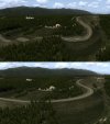
I would personally use AB_Flatten for sloped polys rather that Legacy_LWM_Land _Flatten. I once needed a road grade reconstructed that was built after the mesh data was sourced. I made a line 75m wide with a vertex every 100m or so. I subtracted the lowest elevation from the highest and divided by the number of vertices, then I adjusted each vertex to the height of the previous one plus the calculated value so the line made a perfectly gradual slope as it wound it's way up through the canyon. I converted the line to a polygon and set it as AB_Flatten, the elevations from the points in the line remained intact. I spent a lot of time making other sloped polys to blend it in with the surrounding mesh but the result came out quite nice I thought:

north_hill_before_n_after.jpg


north_hill_before_n_after-jpg.76020

{ This is a quoted post; Jim's original image is restored for educational purposes from a FireFox saved "web page, complete" archive }

GaryGB
 

Attachments

  • north_hill_before_n_after.jpg
    north_hill_before_n_after.jpg
    360.4 KB · Views: 210
Last edited:
Back
Top