- Messages
- 173
- Country

Enhanced Terrain Mesh 10m in MSFS2024: structure, limitations, capabilities and GIS notes
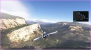
The ETM 10m (Enhanced Terrain Mesh) in Microsoft Flight Simulator 2024 is built from Sentinel‑1 SAR DEM/DTM data and represents the terrain using a grid with a horizontal spacing of approximately 10 meters.In the SDK you can visualize the actual mesh structure: each cell is made of four vertices spaced ~10 m apart, each with an interpolated elevation value.In QGIS, the same cell shows an area of roughly 100 m², with differences between Cartesian and ellipsoidal calculations due to Earth curvature and the WGS84 reference ellipsoid.

1. DEM source characteristics
The Sentinel‑1 SAR DEM used for ETM is derived from radar interferometry.Typical properties:- global coverage
- variable native resolution
- presence of altimetric noise
- need for smoothing and interpolation for simulator use
2. Mesh interpolation
MSFS2024 uses a triangulated irregular network (TIN) built from the grid vertices.Each 10×10 m cell is split into triangles, and the final surface is the result of linear interpolation between vertices.Direct consequence:
 the terrain surface is always smooth between sampled points.
3. Resolution limitations
A 10 m mesh can only represent terrain variations equal to or larger than the cell size.Anything smaller than ~100 m²:- micro‑reliefs
- narrow embankments
- small man‑made structures
- ditches
- minor buildings
4. Working scale: 1°×1° tiles
Our ETM project focuses on large areas, typically 1° latitude × 1° longitude tiles, ensuring:- altimetric continuity
- uniform quality
- consistency across adjacent regions
- optimal performance during compilation and runtime
5. Higher resolutions: when possible
For smaller areas (valleys, airports, local POIs), it is possible to use DEM/DTM with resolutions finer than 10 m, when available.Examples:- 1 m LIDAR
- 0.5–2 m photogrammetry
- high‑density local DEMs

Compared to coarser meshes (30 m, 90 m, 250 m), the ETM 10m:
- preserves real morphology more accurately
- maintains narrow valleys
- avoids excessive flattening
- improves lighting and slope rendering
- enhances VFR realism
- enables much more accurate custom scenery