[
EDITED]
Thank you so much for experimenting with this. I have not yet received feedback about this being an issue, so I will have to prioritize the detailing of the rest of the hospital. But I will look into all of this when I have the capacity. Thank you!
")
I like where you are prioritizing your current efforts; the new Hospital campus building geometry is already looking quite good.
")
If I understand correctly, this is also possible to address my less optimal way of handling terraforming, with multiple terraforming rectangles? I was not aware of the possibilities to adjust a terrain profile out of a rectangle. I will have to experiment with that feature which will be a bullseye in terrain adjustment! Thank you so much, again...!
When I get some more time free, I shall do some tests with the elevation and vector data you so kindly downloaded and linked via PM, to see if one might substitute a new terrain configuration via perhaps, both TIN
and Rectangle methods, so that the Helipad building and surrounding environment fits into / onto MSFS run time rendered terrain in a way more compatible with that seen IRL.
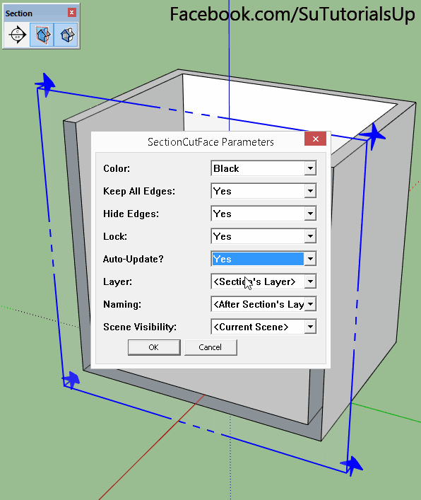
I am a little unsure what you mean about the best practice in reference to the "exclude and replace"? I love best practices
.
Do you mean I should add a exclude rectangle within the area relevant for my custom scenery?
No worries; you are already showing a solid commitment to "Best Practices" by making scenery that is more true-to-life than many other add-ons that limit the scope of their projects to meet the needs of those who may always be at higher flight level Altitudes, and who may never see the ground because they are always inside a cockpit that obstructs ones view of the local scenery at / near ground level.
I am confident that you are likely to keep up that great work, as your endeavors progress further at this- and other- locations.
As time permits, one may find ways to still allow others' work to contribute to "The Big Picture", while using SDK compliant methods with one's own work, to yield a 3D world render at run time in MSFS that is more true-to-life.
When you are ready, I do believe it would be a good idea to implement the 'ExcludeRectangles' within the area relevant for your custom scenery, so that your own work can be seen instead of the MSFS default, or by local 3D tiles imposed by end users who have the "EnjoyItFly-Stavanger" add-on installed.
No rush, but that latter modification I described above, can essentially be a quick procedure using your own existing Project files.
As time permits, you may wish to also correct a small number of fixes for the non-SDK compliant local terrain rendering super-imposed onto MSFS default scenery, by end users who have the "EnjoyItFly-Stavanger" 3D tiles add-on installed; I can show you how to do that, again, via using your own existing Project files.
[
END_EDIT]
Regarding this quote from the MSFS20 SDK Docs:
"
IMPORTANT! When stacking terraforming rectangles, the falloff will only be used for the lowest priority rectangle. All rectangles on top will have their falloff behave as if it was set to 0 and so give the sharpest transition possible"
https://docs.flightsimulator.com/html/Developer_Mode/Scenery_Editor/Objects/Rectangle_Objects.htm
I just read that yesterday (AFAIK, it is a new implementation by Asobo);
You never know what you will stumble across reading through the SDK Docs.

I plan to test it, as I have not yet tried that method of placing a base level terra-forming Rectangle at "Priority 0", then "stacking" / superimposing (1) or more Rectangles on top at a higher Priority.
I hope the base terra-forming Rectangle can be made 1 Meter smaller per each side from its center point, to offset from the minimum 1 Meter sloped "falloff" area, then we would have a smooth and straight Rectangular hole in the ground in which to place 3D objects like the ENSX Helipad.

I'll bet you get a chance to test that before I do, what with all my Holiday commitments.
GaryGB