• Which the release of FS2020 we see an explosition of activity on the forun and of course we are very happy to see this. But having all questions about FS2020 in one forum becomes a bit messy. So therefore we would like to ask you all to use the following guidelines when posting your questions:

    • Tag FS2020 specific questions with the MSFS2020 tag.
    • Questions about making 3D assets can be posted in the 3D asset design forum. Either post them in the subforum of the modelling tool you use or in the general forum if they are general.
    • Questions about aircraft design can be posted in the Aircraft design forum
    • Questions about airport design can be posted in the FS2020 airport design forum. Once airport development tools have been updated for FS2020 you can post tool speciifc questions in the subforums of those tools as well of course.
    • Questions about terrain design can be posted in the FS2020 terrain design forum.
    • Questions about SimConnect can be posted in the SimConnect forum.

    Any other question that is not specific to an aspect of development or tool can be posted in the General chat forum.

    By following these guidelines we make sure that the forums remain easy to read for everybody and also that the right people can find your post to answer it.

Replacing default Island with Photoreal_cont.

Messages
687
Country
us-texas
This illustrates why I try to go out of my way to steer clear of working near water. . .it's a royal PITA, lol.

I have done an exclude to remove the default. . .filled that area back in with a hydro poly and knocked out the area needed to display the new photoreal Island. That portion has gone well. . .kinda, however I am left with what you see in these pics.

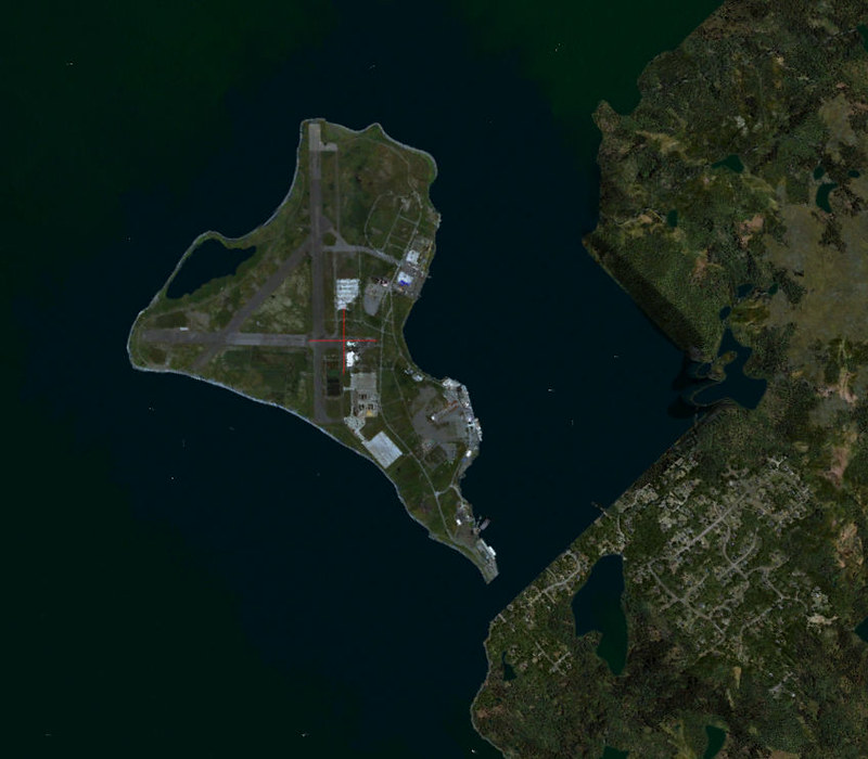
Image1 by Ed Wells, on Flickr

NAS_Argentia-2023-aug-9-002 by Ed Wells, on Flickr

So is this caused by the exclude poly or the Hydro Poly. . . .or both?
 
I would think that is due to the water poly as it is flattened to sea level. In the past, I would smooth out a slope, in your case from the top of the "cliffs" down to the shoreline by using SBuilderX and create a poly the size of the open space and adding elevation points. I would take a little GA plane, move it from point to point and place that elevation at each point. I would then sort of "guesstimate" open areas until I reached sea level (or leave a little altitude and let P3D smooth out the rest. Looked good but just took some time to execute.
 
That will probably be my next step after I figure out why the landmass to the right of the Island is missing. As you can see from the image the QMID cell cuts into the landmass and I need to figure out how to get it back.

QMID13 by Ed Wells, on Flickr

This shows QMID13 and the area of the cell that cuts into the adjacent landmass which is what I am trying to get back.
 
Last edited:
I have no answers, I've tried everything I know to do and all I come up with is either a peninsula with default terrain sticking out under the satellite image or what I've already documented above. Someone out there knows how to fix this, I just need to find the forum where that person resides.
 
Everything within that water poly is going to be at sea level, so you just need to enclose the water only.
I would delete your current water poly. It's going to be easier to make a new poly.

Place your initial points outside of the QMID square on the top left and right corners. Then from outside of the QMID, start tracing the shoreline all the way up and around the peninsula until you exit the QMID again on the left side. Close off the poly.
The poly should now only be covering the water and the land should be visible. In the poly tool mode, right click on the border of the poly and do Slice to QMID 13. Then you just need to delete the polys that got sliced off of the QMID square. You'll be left with a water poly that is perfectly aligned to your QMID.

You may have to play with the left and right most polygon points to get it to align to the default shoreline enough to be hidden by either your aerial or a shoreline.

badlydrawnexample.PNG
 
So obvious when you see it. . .My Math teacher always made a point to tell me I was making it harder than it really was. Apparently I never learned my lesson. Thank you for proving her point, lol

I was so zoned in on how to do an Island (water poly, second poly around the shoreline, "make a hole" and so on) that the obvious escaped me. Many Thanks!
 
Back
Top