
Some observations.
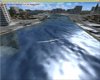
Using the slew mode smost of the rivers in the default FSX do not ascend in a sequential manner. They tend to be more like a roller coaster with very noticeable ups and downs.
I was most interested in the Slartibarfast program (with an excellent tutorial by Scott Gridley) becuase it seemed to cover a fairly large area and made dramatic improvements in the rivers and coastlines (and other aspects). It also seemed to follow the terrain mesh more accurately (it pretty much just layered on top of the terrain and followed the river course more accurately) tho' I might be wrong on this.
With FSX KML there seemed to be a tool that would/could possibly really improve the "realness" of the Landscape Design. However, when I used this program it pretty much did the same thing as the default rivers. There was some discussion about the X and Y ratio and altitude and some other such nonesense related to river polygons but according to what I can see the FSX water polygons are using the so called legacy water on top of terrain. Pleas don't hesitate to correct me if I haven't gotten this correct.
What I am saying is that a combo of slartibartfast and something like FSX KML could really do some magic on the Landscape Design.
Also in my opinion Mesh Terrain should be in Mesh Terrain and Landscape Design should be in a different category that would include Landclass, WaterClass, Region and Seasonal Differences.
________
Harley-Davidson FLSTS
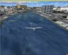
Attachments
Last edited: