Hi Trieu:
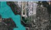
It appears that your airport flatten polygon extends from the center of the airfield to a position
very close to the edge of the water.

If you reduce the extent of that flatten polygon in size so that it does not fully reach the edge of the water, the terrain should slope
downwards from the flatten to meet the water level by the shoreline at an angle which is less steep.
") FYI
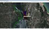
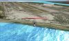
FYI: If you need to further fine tune the shape of the shoreline, you may need to add a small band of
terrain "skirt" at the edge of the airport flatten.
BTW: You may wish to review this thread for info on sloped flattens and terrain 'skirts', while making sure that one's vertices align with the coordinates and altitudes of the airport flatten and the surrounding terrain mesh at the
ex: shorelines by the waters edge:
http://www.fsdeveloper.com/forum/showthread.php?t=425302&highlight=sloped
PS: I am not certain that the semi-automatic "
Snap_To_LOD-21_Grid" feature of
SBuilder for FS9 when preparing terrain vertices for FS9 format vector LWM BGLs ...was ever implemented in SBuilderX, to do the same processing of terrain vertices prior to compilation for FSX format CVX vector BGLs.
 http://www.ptsim.com/forum/viewtopic.php?p=446
http://www.ptsim.com/forum/viewtopic.php?p=683
http://www.ptsim.com/forum/viewtopic.php?p=4056
http://www.ptsim.com/forum/viewtopic.php?p=4520
http://www.ptsim.com/forum/viewtopic.php?p=446
http://www.ptsim.com/forum/viewtopic.php?p=683
http://www.ptsim.com/forum/viewtopic.php?p=4056
http://www.ptsim.com/forum/viewtopic.php?p=4520
If "Snap_To_LOD-21_Grid" was
not implemented in SBuilderX, IMHO, it is advisable to
manually align ones vertices for the triangles of detailed sloped flattens with the FS Quad Matrix LOD-21 Grid vertices, in order to
minimize demands placed on the terrain rendering system at run time ...
especially near detailed airports which will be used by complex aircraft, to allow better overall FSX performance.
Alternatively, one would could pre-process such sloped terrain flatten vertices in SBuilder for FS9 to make use of that version's semi-automatic "Snap_To_LOD-21_Grid" feature, then export them within a *.SBX file to be imported into SBuilderX for final processing and compilation into a FSX CVX vector format BGL.

Hope this helps !
")
GaryGB