MatthiasKNU
Resource contributor
- Messages
- 962
- Country

Hello everybody!
First of all, I'm sorry.
I just needed a little vacation, after millions of square kilometers of photo scenery in Africa.
What could be more logical than a holiday in the beautiful Mediterranean Sea!
So that's how I started working on Mallorca.
I have to say first, I'm not a friend of double development. Nevertheless, I have started a double development.
No, I am not talking about LEPA, the international airport of Mallorca. But from the island themselves.
I was sure that I could create a better photo scenery than the one Aerosoft Mallorca has to offer.
After JustSim also recently released an up-to-date version of LEPA that came without photoscenery, I started to create Mallorca at the end of May, beginning of June.
Well, and today, after more than 1000 hours, I am able to present the project here!
First of all, will it be Freeware? YES!
And not only that, since all the data I have used allow the release, I can also offer the scenery for free download.
Some of you may say, well, a photo scenery is nothing new. Not even of Mallorca.
Mine's new. It is not only a photo scenery, but a full scenery package.
So, what's to be expected? First: 25 GB data. That would have been smaller possible, too, yeah. But not in this quality.
Here is a small feature list:
- 0,5 m/px photoscenery for the entire island, adapted to ORBX openLC colors (LOD17)
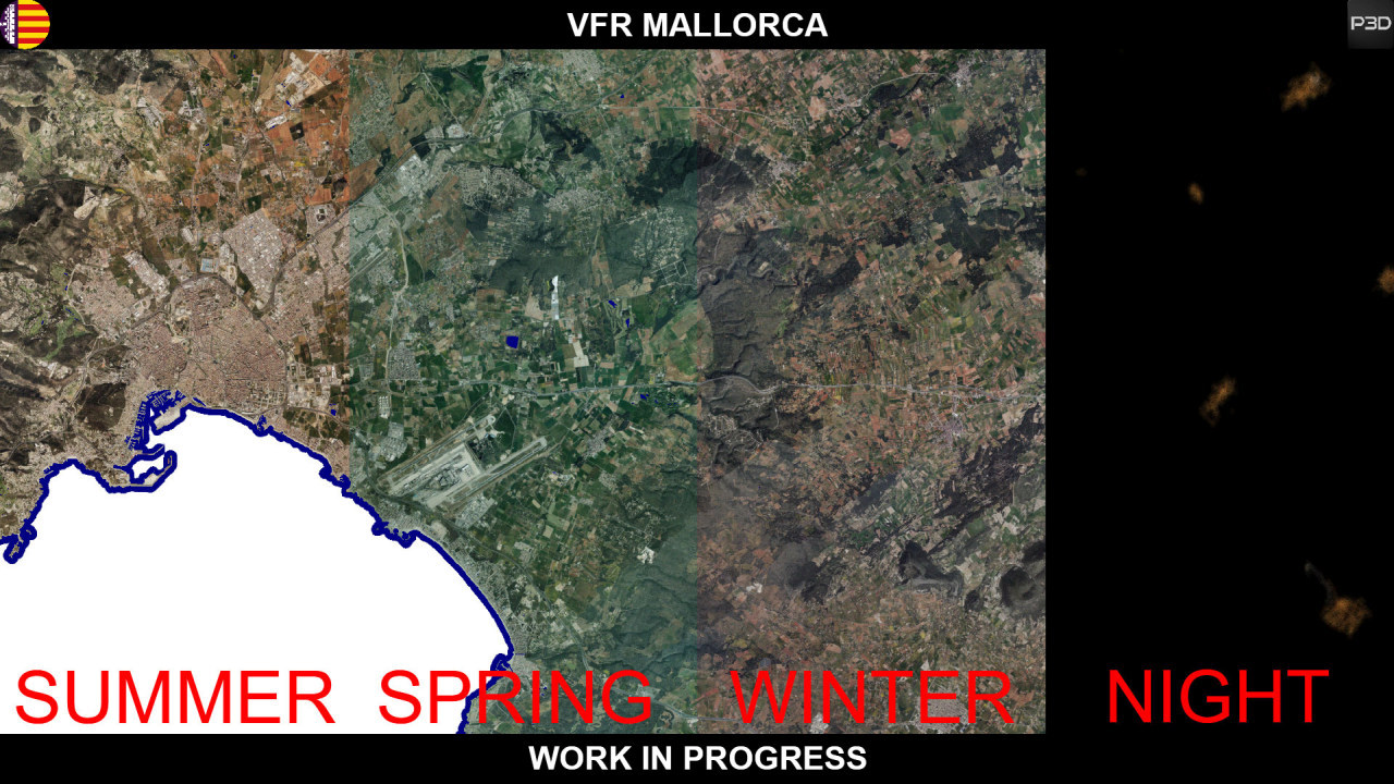
- 3 hand-coloured seasons (Winter, Spring, Summer)
- Night ground textures
- High resolution mesh, based on LIDAR-Data (LOD13) (The most accurate mesh currently available uses only LOD10!)
- Exact differentiation of tree species based on CORINE data with a resolution of 25 m/px
- "Light" sceneries of all airfields in Mallorca except LEPA inculding Aerodrom de Binissalem, Son Bonet, Vilafranca de Bonany, Porto Cristo, Ses Salines and LLucmajor
- LESB Son Bonet with 7 cm/px imagery
- Accurate placed VFR Objects like powerpoles, antennamasts, windturbines or lighthouses
- More than 25 mio. autogen trees
- Extremly dense autogen vegetation
- More than 200.000 autogen buildings
- Use of P3D default objects only for maximum compatibility
- Config tool to customize options according to your needs
- Compatible with ORBX-sceneries, Aerosoft Mallorca Professional and JustSim Palma de Mallorca
- P3Dv4.5 native for best performance
And what does the whole thing look like in the sim? Take a look!
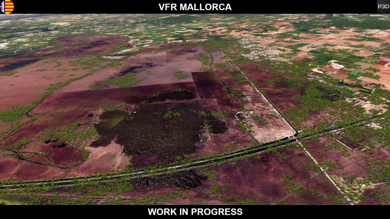
Natural park S'Albufera:
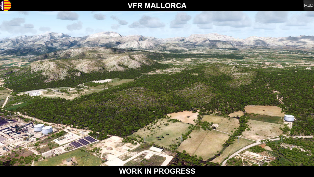
Near Alcudia:
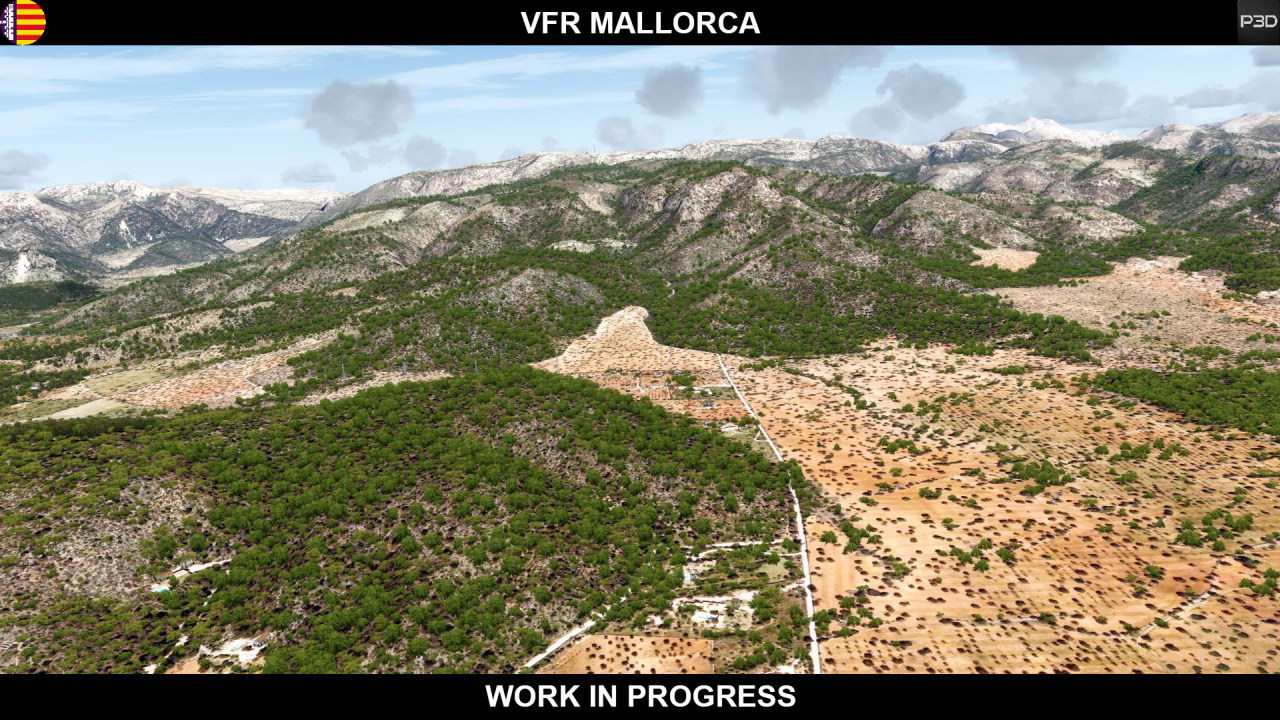
Serra de Tramuntana:
Approaching Palma de Mallorca (in the background the Puig de Randa is visible with its antennas):

And the 3 Seasons:
Okay. Okay. I think I've written enough for today!

First of all, I'm sorry.
I just needed a little vacation, after millions of square kilometers of photo scenery in Africa.
What could be more logical than a holiday in the beautiful Mediterranean Sea!
So that's how I started working on Mallorca.
I have to say first, I'm not a friend of double development. Nevertheless, I have started a double development.
No, I am not talking about LEPA, the international airport of Mallorca. But from the island themselves.
I was sure that I could create a better photo scenery than the one Aerosoft Mallorca has to offer.
After JustSim also recently released an up-to-date version of LEPA that came without photoscenery, I started to create Mallorca at the end of May, beginning of June.
Well, and today, after more than 1000 hours, I am able to present the project here!
First of all, will it be Freeware? YES!
And not only that, since all the data I have used allow the release, I can also offer the scenery for free download.
Some of you may say, well, a photo scenery is nothing new. Not even of Mallorca.
Mine's new. It is not only a photo scenery, but a full scenery package.
So, what's to be expected? First: 25 GB data. That would have been smaller possible, too, yeah. But not in this quality.
Here is a small feature list:
- 0,5 m/px photoscenery for the entire island, adapted to ORBX openLC colors (LOD17)
- 3 hand-coloured seasons (Winter, Spring, Summer)
- Night ground textures
- High resolution mesh, based on LIDAR-Data (LOD13) (The most accurate mesh currently available uses only LOD10!)
- Exact differentiation of tree species based on CORINE data with a resolution of 25 m/px
- "Light" sceneries of all airfields in Mallorca except LEPA inculding Aerodrom de Binissalem, Son Bonet, Vilafranca de Bonany, Porto Cristo, Ses Salines and LLucmajor
- LESB Son Bonet with 7 cm/px imagery
- Accurate placed VFR Objects like powerpoles, antennamasts, windturbines or lighthouses
- More than 25 mio. autogen trees
- Extremly dense autogen vegetation
- More than 200.000 autogen buildings
- Use of P3D default objects only for maximum compatibility
- Config tool to customize options according to your needs
- Compatible with ORBX-sceneries, Aerosoft Mallorca Professional and JustSim Palma de Mallorca
- P3Dv4.5 native for best performance
And what does the whole thing look like in the sim? Take a look!
Natural park S'Albufera:
Near Alcudia:
Serra de Tramuntana:
Approaching Palma de Mallorca (in the background the Puig de Randa is visible with its antennas):
And the 3 Seasons:
Okay. Okay. I think I've written enough for today!
Last edited:

 Do you know what ?
")


")


