Hi Chris:
Search on
BLN of the SBuilderX
Help file; there you will also find a link to the sections on "
Append - Surfer BLN"
If you follow the link to the "
Appendix" section of the SBuilderX.ini file, of particular note will be the
[BLN] section, and the
Join parameters.
For incidental discussions on SBuilder features used to create a "
closed Line", see:
[
EDITED]
CAVEAT: Take note of this
SBuilderX.INI file parameter value regarding the '
MakeClosedLineFromPoly' function by SBuilderX author Luis Sa':

Luis Sa said:
at PTSIM Forum:
Hi Horst,
I am divided in making the scenery of Portugal and in keeping track of the changes that I introduce in SBuilder. In making the scenery I discover several additions that would be useful to include in SBuilder. When I finish the scenery (it is approaching the end) I will update the SBuilder Help. I will try to have the last compiled EXE available in file sbxxx.zip. I will also try to post here (or avsim) the additions that worth to announce.
The problem with MakeLine (from Poly) is a recursive one. The problem has to do with BLN format or with my interpretation of it. Say that you import a BLN set of N points. This set of points will be a line if Point1 is different from PointN. If Point1 = PointN then the set is a polygon. I saw this in:
Am I right? When I save a 27-point polygon, I save 28 pairs of coordinates, with Point28 = Point1.
If you have a N-point line with Point1 = PointN and you export to BLN and import again, you will get a polygon! Did you follow me?
Having said that I will change "MakeLine from Poly" to have repeated points! I will make sure that "MakePoly from Line" will not create a duplicate point if the line is closed!
I will be making the change and I will upload sbxxx.zip. Wait until I confirm this.
<font color="red">Edit 5 minutes later!</font id="red">
Horst: there is a switch in the INI file! I forgot I had it!
MakeClosedLineFromPoly=False ; lines will be be closed when using Make Line
Regards, Luis
[
END_EDIT]
Whereas a legacy format 'minimal' source data set for Poly-lines is X,Y,Z (Lon,Lat,Alt), SBuilderX can import both ESRI
*.SHP and legacy format Surfer
*.BLN files that contain more fields than just X,Y,Z ...which can be used to set Start and End line width to establish a 'taper'.
The SBuilderX
*.SHP Append method requires an interactive process to set Start and End width for tapered poly-lines to be created from X,Y,Z or other multi-feature line source files.
Obviously it would be be a lot of work to manually assign such a set of parameters to each individual line during import, so one can do this in the
SBuilderX.ini file prior to the
ex:
*.BLN Append procedure, assuming one has configured the derived source data in QGIS before exporting the
*.BLN source file to be Appended by SBuilderX.
FYI: A discussion (in the context of SBuilder for FS9) of SBuilder options when working with these tasks ...is here:
I've been trying to learn SBuilder (and AutoASM but that's a different problem!) and need some help on approach.I am fixing some default scenery, consisting of islands and terrain within. I have landclass and waterclass assigned as needed already (and mesh is OK too).I have BLN files generated fr...

www.avsim.com
It may also be possible to perform these functions in Google Earth and/or FSX-KML, then use Dick's KML2BLN utility to convert
*.KML data for a
*.BLN to be Append-ed by SBuilderX.
Optionally, one may just intend to only assign a 'taper' to line segments rather than converting Poly-lines to Polygons.
But, preferably, one may identify a method to define Poly-line segment widths, convert them into Polygons in QGIS, then merge those Polygons having matching Water Class texture types ...so that one has a way to define these attributes semi-automatically when preparing CVX vector GUID assignments.
In the event that a SBuilderX 'Append' has too limited of a feature assignment function, one may instead be able to create a fully configured SBuilderX EXchange
*.SBX ASCII text file by editing attributes for Poly-lines in that format, then 'Importing' that source to SBuilderX.
Here's a QGIS work-flow to create attributes for width as a function of 'flow direction' along defined line segments:

In 2012 I published a post on mapping the then newly released Tirol river dataset. In the comments, reader Michal Zimmermann asked: Do you think it would be possible to create a river stream which …

anitagraser.com
BTW: Have you seen the
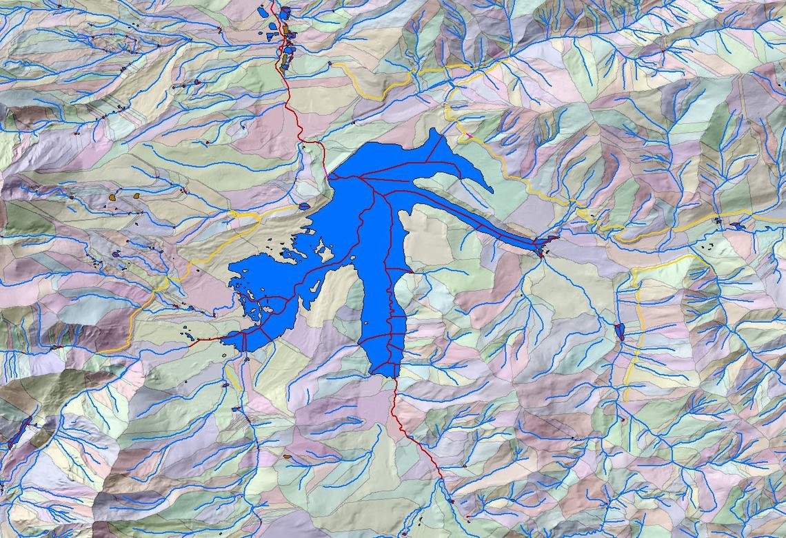
new USGS attributes now being made available for Hydrology ?

The National Hydrography Dataset (NHD) represents the water drainage network of the United States with features such as rivers, streams, canals, lakes, ponds, coastline, dams, and streamgages. Note – As of October 1, 2023, the NHD was retired. NHD data will continue to be available, but no...

www.usgs.gov
The NHDPlus HR is a geospatial dataset depicting the flow of water across the Nation's landscapes and through the stream network. The NHDPlus HR was built using the National Hydrography Dataset High Resolution data at 1:24,000 scale or more detailed, the 10 meter 3D Elevation Program data, and...
www.usgs.gov
The flow network embedded in the NHD is what gives it its analytic power. A set of NHDPlus HR attributes called the Value-Added Attributes (VAAs) boost this power by pre-calculating a number of network characteristics to make network analysis easier and richer. Several of these VAAs are...
www.usgs.gov
Some related Search results on this query at Google which may also prove informative:
Hope these ideas help a bit more with evaluating the feasibility of this aspect of your quest.
")
GaryGB