
is terraforming is working now or what?!ZIP the layout.json and manifest.json files into backup, then delete the originals in:
[MSFS-2020_Packages install path]\Official\OneStore\asobo-airport-heca-cairo\ ...sub-folder
Now if I start a flight at HECA, the A/C is at the altitude assigned by a custom airport BGL (in a Project or in a \Community sub-folder).
This looks promising.")
-
Which the release of FS2020 we see an explosition of activity on the forun and of course we are very happy to see this. But having all questions about FS2020 in one forum becomes a bit messy. So therefore we would like to ask you all to use the following guidelines when posting your questions:
- Tag FS2020 specific questions with the MSFS2020 tag.
- Questions about making 3D assets can be posted in the 3D asset design forum. Either post them in the subforum of the modelling tool you use or in the general forum if they are general.
- Questions about aircraft design can be posted in the Aircraft design forum
- Questions about airport design can be posted in the FS2020 airport design forum. Once airport development tools have been updated for FS2020 you can post tool speciifc questions in the subforums of those tools as well of course.
- Questions about terrain design can be posted in the FS2020 terrain design forum.
- Questions about SimConnect can be posted in the SimConnect forum.
Any other question that is not specific to an aspect of development or tool can be posted in the General chat forum.
By following these guidelines we make sure that the forums remain easy to read for everybody and also that the right people can find your post to answer it.
You are using an out of date browser. It may not display this or other websites correctly.
You should upgrade or use an alternative browser.
You should upgrade or use an alternative browser.
MSFS20 Airport fixed elevation plz help!
- Thread starter Aboud
- Start date


is terraforming is working now or what?!
Hi Aboud:
Yes, it appears that a Polygon for terraforming may now work in conjunction with having disabled MSFS' Premium HECA airport.
But I recommend starting first with disabling MSFS Premium HECA airport via *.JSON ZIP backup, followed by *.JSON deletion.
Then edit the Altitude for your replacement HECA airport ARP and RWYs, while also setting HECA's airport attribute to "Flatten".
Before proceeding with the work creating your own custom terraforming Polygon for the HECA airport boundary, consider this:
As you may know, at HECA, there are highways with interchanges / overpasses which are long 3D models, and require some special terraforming work, so it will be important to work through a number of steps in sequence, in order to minimize the amount of work this task may involve.
If you wish to change the way HECA blends into nearby terrain for the adjacent city, there will also be some extra work required.
If you are still unfamiliar with all the steps required, and how to perform them in ADE and/or MSFS DevMode GUI, we can help.
However, composing that help into text within this thread may take some time, so let us know what you need help with at this point.
We also need to know if you actually have MSFS' Premium HECA airport installed, and if so, where is it located (drive letter\folder etc.)
For example, on my computer, the MSFS' Premium HECA airport
D:\MSFS-2020_Packages\Official\OneStore\asobo-airport-heca-cairo\layout.json
D:\MSFS-2020_Packages\Official\OneStore\asobo-airport-heca-cairo\manifest.json
GaryGB
Last edited:
Hey Gary, I did everything u stated here and terraforming is not working also.Hi Aboud:
Yes, it appears that a Polygon for terraforming may now work in conjunction with having disabled MSFS' Premium HECA airport.
But I recommend starting first with disabling MSFS Premium HECA airport via *.JSON ZIP backup, followed by *.JSON deletion.
Then edit the Altitude for your replacement HECA airport ARP and RWYs, while also setting HECA's airport attribute to "Flatten".

Attachments
We also need to know if you actually have MSFS' Premium HECA airport installed, and if so, where is it located (drive letter\folder etc.)
For example, on my computer, the MSFS' Premium HECA airport*.JSONfiles are here:
D:\MSFS-2020_Packages\Official\OneStore\asobo-airport-heca-cairo\layout.json
D:\MSFS-2020_Packages\Official\OneStore\asobo-airport-heca-cairo\manifest.json
GaryGB
Hi Aboud:
Do you- or do you not- have MSFS' Deluxe Additional Handcrafted Airport HECA installed ?
In other words, do you have MSFS Deluxe version of 'FS 2020' installed ?
https://www.gamersbynight.com/microsoft-flight-simulator-buy-edition/
GaryGB
Last edited:
Yes i have deluxe version (I bought the standard then i upgraded to the highest version)Do you- or do you not- have MSFS' Deluxe Additional Handcrafted Airport HECA installed ?
The highest version is Premium Deluxe, which AFAIK, should contain MSFS' Deluxe Additional Handcrafted Airport HECA.Yes i have deluxe version (I bought the standard then i upgraded to the highest version)
OK, so did you first use MSFS SDK DevMode to edit the HECA ARP and Runways altitude to 116 Meters AMSL, Flatten, Save, then Build ?
If so, did the MSFS display of the airport show the user A/C at an altitude of 116 Meters / 370 Feet AMSL ?
PS: What time zone are you currently located in ?
GaryGB
Last edited:
Ok, so from where i can change the airport altitude, tell me how u did it so i can do it same as uOK, so did you first use MSFS SDK DevMode to edit the HECA ARP and Runways altitude to 116 Meters AMSL, Flatten, Save, then Build ?
No it shows 343 feet amslIf so, did the MSFS display of the airport show the user A/C at an altitude of 116 Meters / 370 Feet AMSL ?
Eastern European Standard TimePS: What time zone are you currently located in ?
Time zone in Cairo (GMT+2)
Ok, so from where i can change the airport altitude, tell me how u did it so i can do it same as u
With the Project loaded, enable display of the "Gizmo" dialog box:
MSFS SDK DevMode > Scenery Editor > View Menu > check: Gizmo
Project Editor > click: Scenery BGL > Scenery Editor > click: Airport HECA > Gizmo > alt field > select / type over existing value
NOTE: IIRC, in MSFS SDK, alt. Values may be entered as either Feet or Meters if you use proper letter suffix after Altitude numeric value
* Meters: over-strike existing Altitude in that field with 116.0 M: press <Enter>
...or:
* Feet: over-strike existing Altitude in that field with 380.576338F: press <Enter>
Regarding the "Flatten airport" feature, see:
https://docs.flightsimulator.com/ht.../Objects/Airport_Objects.htm?rhhlterm=Flatten
"Apply Flatten
Checking this option will auto-generate terraforming rectangles within the bounds of the airport test radius to flatten the terrain. These rectangles are internally defined and not rendered in the world as objects, although their effects will be visible on the terrain."
No it shows 343 feet amsl
That Altitude will vary with A/C position at HECA, and type of A/C used (due to gear height from ground to 3D model datum of A/C etc.)
Eastern European Standard Time
Time zone in Cairo (GMT+2)
OK, so it is just past 1:30 P.M. here in Chicago area of USA.
GaryGB
Last edited:
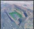
hey Gary, I did what u have told me and guess what it doesn't change!!!!! but here is a thing, in a moment of sadness and hating the situation I tried to spam clicking on the priority of the polygon until it worked
 so in order to make the terraforming work in this cursed airport is to set the priority to over 50, interesting!!!!!!!!
but here is a thing, in a moment of sadness and hating the situation I tried to spam clicking on the priority of the polygon until it worked so in order to make the terraforming work in this cursed airport is to set the priority to over 50, interesting!!!!!!!!Attachments

Hi Aboud:
Congratulations on your success with getting a HECA airport terraforming Polygon to work at a +50 Priority setting.
I had not yet tested using higher priority numbers, as the SDK docs indicated that default scenery was only using layers up to 10 or so.
I understand that you may subsequently wish to use terraforming to blend HECA into the surrounding terrain.
But, IMHO, you may not need to do as much work if you first correct the ARP and RWY Altitudes, then apply the "Flatten" setting for the ARP display radius ...prior to fine-tuning your terrain blend at the edges of the airport area with such a terraforming Polygon.
In my own test scenario, after having first disabled the HECA *.JSON files cited above, I corrected the ARP and RWY Altitudes, and applied the "Flatten" setting for the ARP display radius; then I was able to render a terraforming Polygon for the airport at +12 Priority.
It is important to first check and see if MSFS re-installed the *.JSON files cited above when it next re-started and checked for updates.
If in fact MSFS did re-install the *.JSON files cited above when it re-started and checked for updates, they must be deleted again.
Apparently MSFS did this on my installation, so I had to delete the files again; we may need a better way to disable the Deluxe HECA.
So, in summary, I was able to change the scenery render to the specified Altitude by only editing HECA airport parameter values.
I was then able to get a terraforming Polygon to render at only +12 Priority.
I shall probably now test HECA with its *.JSON files cited above enabled, then see if a terraforming Polygon will render at +50 Priority.
FYI: I am trying to find a less complex solution to enhance HECA using a default airport boundary SHP polygon derived by CvxExtractor.
But, the learning curve for most would-be developers in utilizing ESRI SHP files derived via that method may be impractical to take on.
We could otherwise save a lot of work by being able to import / edit external GIS-data set ESRI SHP files into ADE and/or SDK DevMode.
ADE / DevMode now forces us to make Polygons by manual clicks to create all vertices for each such scenery object in one's terrain.
I may post more on this pending progress in achieving a simplified GIS app work-flow to offset effort of manual Polygon creation.
GaryGB
Last edited:
ADE will not open APX56210.bgl as it uses Patrick's code. I was able to decompile with msfsbglxml and then extract the code for HECA with a text editor. It is attached.
Here's a HECA project attached as a zip file. I cleaned up the XML code for the airport a bit... the compiler isn't perfect. I deleted the airport flatten, so you shouldn't get the odd cliffs surrounding the airport. Hope this works for you.
Hi Dick:
All my efforts in this thread to work with your generously contributed files cited above for MSFS HECA airport, were based on use of MSFS SDK DevMode GUI, as ADE Alpha-21 HF-5 was unable to process either of the (2) versions of HECA you attached previously in the OP's threads.
By substituting Patrick Germain's new Bgl2020.dll included in BglViewer2020_2_18, ADE was able to process your BGL / XML HECA files.
")
Many, many thanks to Patrick Germain for all the work he has done with his brilliant utilities.

And thanks again for your contributions here with Aboud's project, as well as for all your help in facilitating Patrick Germain's ongoing efforts.
GaryGB
Last edited:
I wish this method work with me but i have tried it many times and sadly it didn’t work, u r right that doing polygons only requires a lot of work but i think that will be the only way in my case, after that i want to thank u gary for ur help and effortBut, IMHO, you may not need to do as much work if you first correct the ARP and RWY Altitudes, then apply the "Flatten" setting for the ARP display radius ...prior to fine-tuning your terrain blend at the edges of the airport area with such a terraforming Polygon.
In my own test scenario, after having first disabled the HECA *.JSON files cited above, I corrected the ARP and RWY Altitudes, and applied the "Flatten" setting for the ARP display radius; then I was able to render a terraforming Polygon for the airport at +12 Priority.
