• Which the release of FS2020 we see an explosition of activity on the forun and of course we are very happy to see this. But having all questions about FS2020 in one forum becomes a bit messy. So therefore we would like to ask you all to use the following guidelines when posting your questions:

    • Tag FS2020 specific questions with the MSFS2020 tag.
    • Questions about making 3D assets can be posted in the 3D asset design forum. Either post them in the subforum of the modelling tool you use or in the general forum if they are general.
    • Questions about aircraft design can be posted in the Aircraft design forum
    • Questions about airport design can be posted in the FS2020 airport design forum. Once airport development tools have been updated for FS2020 you can post tool speciifc questions in the subforums of those tools as well of course.
    • Questions about terrain design can be posted in the FS2020 terrain design forum.
    • Questions about SimConnect can be posted in the SimConnect forum.

    Any other question that is not specific to an aspect of development or tool can be posted in the General chat forum.

    By following these guidelines we make sure that the forums remain easy to read for everybody and also that the right people can find your post to answer it.

Adjusting the ILS heading

Messages
115
Country
ca-britishcolumbia
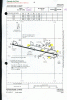
Flying into YKA from the east is flying down a tight valley. The ILS now is at a stock heading set at 285.0000 and suggests a variation of -19.00 which I believe is currently -16.00 but I'm not betting on that.

The ILS currently keeps you close to the higher terrain side and then requires a slight course NDB (offset) correction to center on the runway a short distance out. I believe that NDB predates the ILS install as the charts show a clean 266M all the way in.

OK here's what I'd like to do ... move the heading of the ILS more into the center of the valley where the approach is clearer and would keep the Terrain Man from yelling at me for the 20 mile drive in .

Can I safely monkey with the 285.000 heading (I presume this is True as the Mag is 266) to alter the approach or is that ill advised?

Also ... there has never been a GS at this airport however I decided to add one ... I'm not sure that it's working and wonder if FS is preventing it from functioning since it's not one there in fact ... even today.

You can appreciate that a clear drive down the valley with some height below you would make the GS a nice addition.

Ken
 

Attachments

  • ILS.jpg
    ILS.jpg
    98.2 KB · Views: 590
Can you change the heading of the localizer? Sure it's your version of the airport. If ADE lets you change the heading in the properties box then go ahead. FSX doesn't compare your airport to the stock and make changes. IE you can add a GS if you want. FSX excludes the stock airport and uses yours. You can see if the glideslope is active by tuning to the localizer frequency and looking to see if the glideslope needle becomes active provided of course that you are in the vicinity of the GS.

Ed
 
I thought that would be the case but I wanted someone else's finger on the trigger. If it was in magnetic degrees it would be a little bit easier to adjust but whatever that 285.000 is remains a guess. One thing is certain I can always get back to that setting if I can't figure it out. But all I have to do is equate that 285.0000 to 266M ... and that's where the science eludes me. Whenever that 285.000 was set is certainly out of date now and maybe that's why being on it causes hugging the mountains today. WestJet use it ... maybe I should ask them!!!

Trial and error will be my tool then.

Thanks for the reply,

Ken
 
Keep in mind that scenery data (including magvar) is fixed when MS creates the scenery data files for that version of FS. For FS9 it's 2003, for FSX, around 2006 (more exact dates have been stated elsewhere). The values of these items today is not really relevant, unless you use today's charts (instead of charts from 2006 (assuming FSX), which would be the most accurate). If so, you will need to take into account the change in magvar between the data of your sim's data and the date of your charts. Then add/subtract that value from the headings on your charts, and those are the headings that should be used for things like the ILS, etc. in the sim.

Hope this helps,
 
Runway and localizer headings are always true, so should be the same today as they were a while back.

MS's representation of BC interior terrain leaves a lot to be desired. Chances are, your difficulty is due to the hills being in the wrong place. Unless you want to make a turn over the threshold, you'll also have to adjust runway heading to the same as your localizer.

Don
 
Those are valid comments for which I thank you.

I thought this might be a little more complicated than just playing with the true hdg so I will do some research before making any changes. The chart is clear on the 266 hdg
But I dont know its date

YKA confirms the current var is 19 which sggests the 285.000 is correctly set.

Don's comment about the terrain being out may have some real merit.

Much appreciate you thoughts.

Ken
 
Hi,

On my printed charts, the ILS and runway headings are magnetic. Thus they will be different today than they would have been earlier.
 
But the true heading of the runway won't have changed. In the 2010 version of Nav Canada's CAP, the main runway heading is shown as 084/264 with a mag variation of 19E, yielding a true heading of 103/283.

A couple of years ago, I placed the six beacons at CYKA for a flight training school. When placed in the correct geographic location, their elevations were way-off. To get the right elevations (which seemed more important to the school), I had to adjust the location of several of them substantially. So, I know that the MS stock terrain elevations around CYKA leaves a lot to be desired.

Interestingly, the chart shows a localizer ILS heading of 266 magnetic while the runway heading is 284. So, there would appear to be a slight turn required over the threshold. To accomplish this, you are going to have to offset the localizer position slightly to the north of the runway centerline. Also, you should note that NAV Canada only states heading in whole degrees. You may need a more precise value to make it all work.

Hope this helps.
Don
 
This discussion is causing me to inspect my newly minted ade yka and check the rwy heading ... I may have moved it to an incorrect hdg without thinking it through when I lengthened it from 6000 to 8000 feet.

I'm in hospital and hope to get sent home tomorrow and I'll cofirm where that piece of the puzzle lies
in my next post. I have that sinking feeling I may be the cause of the prob.

Many thanks for your help and interest! Back to you shortly.

Ken
 
Don, I don't understand, why is the true heading relevant? The true heading of the runway is NOT listed on any charts I have, and thus you have to take into account the change in magvar to be able to use the magnetic headings that are listed. If the magnetic heading is 084 using 2010 charts and it was 080 (hypothetically) in 2006, you will be off 4 degrees when approaching the runway using that chart. Subtracting 4 degrees from all headings given on that chart will give you the correct course to fly in this example.
 
I was referring to ADE parameters (which are specified as true) while I hadn't recognized you were referring to flight parameters. So, resulting confusion is not surprising.

As I said before, NAV Canada charts record magnetic headings together with a dated mag variation and an annual rate of change (which I neglected to mention earlier) With those three parameters one can calculate the true heading within a precision of about one degree. (Greater precision requires other references.)

I know from experience that the hills surrounding Kamloops in MS stock terrain don't match real life. Since Ken was concerned that an ILS approach brought him too close to the hills, I was reminding him that the published ILS heading at YKA differs slightly from runway heading and prompting him to ensure the runway and ILS headings he has specified (as true) to ADE do reflect real life.

If they do, then it seems he's going to have to deviate from real-life parameters to obtain an acceptable approach (or buy better mesh).

Don
 
OK I'm back and I hope they fixed me.

A quick review of the facts that I've got suggest this is a bit of dog's breakfast ...

1) See Runway 08 ADE (attached) data showing a true hdg of 102.4300 and if the 285.000 is correct for rwy 26 then that minus 180 says it should be 105.000. How the ILS and the RWY are described from both direction escapes me and I'm sure I had nothing to do with that.

2) Chart 1 (Canada Air Pilot) shows 08/26 with flight hdgs of 084/264 ... this chart is dated May 2012

3 Chart 2 (Jeppesen) shows flight hdgs of 086/266 and is not clearly dated but suggests around 2000. It also has a disclaimer "for flight simulation only"

It looks to me like chart 1 is more reliable and the suggestion of a flight hdg of 264 would be probably just what I need to get me out a couple of degrees away from the terrain and over the river. It also suggests the offset NDB is no longer used and the ILS will put you down right on the marks.

If you gentlemen see my assumptions as valid Magnetic flight hdgs should be changed to 084/264 and the the True hdgs ??? I have no idea except that CYKA currently broadcast 19 deg variation. Certainly the 08 True seems to be nonsense?

As for Don's comments about the terrain being unreliable I thought I should add that I have UTX Canada right below my AddOn and Orbx's coastal PNW below in the library and I wonder if that doesn't change the parameters used by FS originally.

What would you guys do with this ...?
 

Attachments

  • CYKA-Chart-1.gif
    CYKA-Chart-1.gif
    1,001.2 KB · Views: 1,016
  • CYKA-Chart-2.gif
    CYKA-Chart-2.gif
    1,005.8 KB · Views: 1,243
  • Runway08 HDG.jpg
    Runway08 HDG.jpg
    99.7 KB · Views: 498
  • ILS.jpg
    ILS.jpg
    98.2 KB · Views: 500
I'd be inclined to believe CAP. Based on the current NAV Canada CAC, the true heading of Rwy 08 is 084 (Mag Hdg) + 19 (2003 Var) + 2.4 (12 years at 12'/yr), = 105.4 +- 1deg - call it 105. You might be able to get a more precise number from the City of Kamloops online maps or, if you trust it, Google Earth. For the latter, capture the location of the thresholds at the centerline and do some trigonometry.

UTX Canada doesn't include terrain. Orbx PNW does, and its likely to be much more accurate than stock terrain. Given that you do have PNW, then your too-close-to-the-hill approach is likely a result of you not offsetting your localizer heading by the requisite 2 degrees, (i.e., 266 magnetic or 107 true)

However, because FSX's mag variation has failed to keep up with the real world, you're going to have to fly a couple degrees (magnetic) higher than advertised - or knock 2 degrees off all your ADE true headings.
Don
 
1) See Runway 08 ADE (attached) data showing a true hdg of 102.4300 and if the 285.000 is correct for rwy 26 then that minus 180 says it should be 105.000. How the ILS and the RWY are described from both direction escapes me and I'm sure I had nothing to do with that.
The runway heading is for the base end, the lower number runway.

The localizer heading is for the localizer and doesn't match the runway because it is offset from the runway.

The Jepp SIMchart calls that out.

This chart shows it being offset 2.2°...

Kamloops.jpg


3 Chart 2 (Jeppesen) shows flight hdgs of 086/266 and is not clearly dated but suggests around 2000. It also has a disclaimer "for flight simulation only"
That chart is dated 9 APR 04 and remember, those headings have nothing to do with the runway.

Though if you subtract 2 degrees from 266 you get 264 which matches chart #1.

It looks to me like chart 1 is more reliable and the suggestion of a flight hdg of 264 would be probably just what I need to get me out a couple of degrees away from the terrain and over the river. It also suggests the offset NDB is no longer used and the ILS will put you down right on the marks.
There is nothing on that chart to suggest the NDB is no longer used and it is in fact a key element of the approach.

The localizer points right at the NDB and it is used in the approach. especially if the DME is out.

If you gentlemen see my assumptions as valid Magnetic flight hdgs should be changed to 084/264 and the the True hdgs ??? I have no idea except that CYKA currently broadcast 19 deg variation. Certainly the 08 True seems to be nonsense?

If you change the approach heading from 266 to 264 it will put you closer to the mountains on the north side of the river. Isn't that going to make matters worse?

Also, if you change the localizer heading, so that it no longer points at the NDB you will mess up the approach code.

And if you want to add a glideslope you better make it steeper than the 3.5 degrees you now have or you will be really close to the mountains, if not flying through them.

If you use chart #2 as a base, you descend from 4000 feet to the runway at 1133 feet in 3.8 miles, which is 2867 feet, or 2817 feet if you cross the threshold at 50 feet. That is about 741 feet per mile or 7.0°. At a ground speed of 135 knots you will need to descend at about 1665 feet/minute, that is a steep descent.

If that is what those Westjet three-seven pilots are doing, they are earning their money.

cheers,
Lane
 
Welcome to the fray Lane,
I wish I was competent enough to swim in these shark infested waters with such a knowledgeable group but from the sidelines it's an interesting and educational experience.

However, let me make a few assumptions and see if they "fly"!

1) When they finally talked WestJet to come into YKA they had to install the ILS and lengthen the runway. I think this happened in 2009. Interesting that I used to fly in on a 737-300(?) with Pacific Western and those pilots were damned good at using the NDB, a minimal ceiling and their eyes.

2) I can't refute your suggestion that the ILS points to the NDB in Jepp chart but it strikes me as a bit silly to ILS to the NDB and then jog in to the runway when the CAP chart suggests a straight in at 264 rather than 266 ... the latter 2 degs are probably enough to get your ass out into the valley enough and take the runway straight in. If that is the case it resolves two problems ... the terrain and the jog. The NDB would still be useful in the event of the ILS down. I should phone the airport and get the straight goods from one of the horse's mouths.

3) Thanks for your GS suggestion. I haven't been able to make it work in a couple of tries and really just guessed at the 3.5. The approach is a little over 20 miles from Felco and you can see the terrain gets down to 3000 ft in that area and if you move out into the river you get that extra 2000 to play with. Because as the terrain doesn't stay at 3000 on that approach, I'm guessing that's why they don't have a GS there.

4) Of course The Dash 8 guys don't bother with the Felko approach and hand fly straight in to YKA and then go straight in ... but they do it at least three times a day and they're kinda good at it.

5) So would you agree it is likely that the rwy 08 true heading was for the beacon ... which seems to make sense but assuming I go ahead and try the CAP approach I guess I'd have to change that True to 105, and use flight hdg 264, and leave the runway designations as is?

After all you'd have to agree that I'm probably right and WestJet, Horizon and Jazz are all crazy!!!!

Very much enjoyed your participation in this thread.

I think I'll give is a bash and if it works I'll blab it all over the forum otherwise ... silence will prevail ...

Best to all,

Ken

PS In the probable event that I'm not making a lot sense cut me some slack ... I'm trying to get the anaesthetic gas out of my system after a three hour "procedure" yesterday.
 
Being that I am a bit of a terminology nerd I will point out that technically RWY 26 doesn't have an ILS, even though the ADE dialogs call it that.

Without a glideslope it can't be an ILS and is a localizer approach, or in this case a LOC/DME.

However looking at Google Earth (imagery dated 05-25-2012) I do see a localizer and glideslope on RWY 08, so I would expect an ILS approach there. My most current CAP (2010) doesn't list an ILS for 08 so it must be newer than that. I do still see the NDB transmitter in GE.

I see nothing in the CAP charts to suggest an inbound course of 264. The only chart that shows that is the airport diagram which is only giving the runway heading, not the approach course.

As for what you want in the sim, I suggest you forget about magnetic headings and tweak the localizer heading in ADE (which is a true heading) until you get an approach course you like.

The magnetic heading of a localizer is kind of a moot point anyway as, other than a quick check to make sure you are inbound and not outbound, the last gauge you would concern yourself with on a localizer approach is the whiskey compass. You would be following the needle and if there is any kind of crosswind your magnetic heading won't match the charts anyway.

As for the original LOC/DME approach and the NDB, the NDB is necessary if the DME goes down as it is your only reference to the runway for vertical positioning.

In fact, without the DME the approach starts at the NDB.

Anywho, I hope you can get it the way that you want it.

cheers,
Lane
 
4) Of course The Dash 8 guys don't bother with the Felko approach and hand fly straight in to YKA and then go straight in ... but they do it at least three times a day and they're kinda good at it.

They are probably flying the RNAV approach to rwy 26 which is straight in from Waypoint TUDUD 11 NM from threshold.

fsscr010.jpg


Microsoft inadvertently misplaced the localizer antenna. My picture shows the correct location of the Localizer antenna after you lengthen the runway to the 8000 ft.

fsscr000.jpg
 
And, as you can see, the localizer heading is slightly higher than the runway heading - at 266 -as shown on the LOC/DME CAP chart.

Don
 
Microsoft inadvertently misplaced the localizer antenna. My picture shows the correct location of the Localizer antenna after you lengthen the runway to the 8000 ft.
No they didn't.

If you look at the old imagery in Google Earth you will see that the localizer has been there for quite some time.

Capture.JPG

Well, it appears to have moved a couple feet when they installed a new array. For all practical purposes it has always been there.

cheers,
Lane
 
OK, I was wrong they missed it by this much...

Capture.JPG


...the localizer should be centered on the marker, based on coordinates from GE.

cheers,
Lane
 
Back
Top