Hi Davide:
IIUC, this is for LICR Reggio Calabria airport.
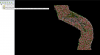
You have already done some very nice work there, as seen in your screenshots thus far.

Log into Facebook to start sharing and connecting with your friends, family, and people you know.

www.facebook.com
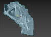
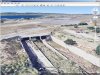
If you wish to add some more high detail terrain enhancement to the surrounding environment at LICR, you may need to use both custom local terrain mesh and a 3D model for this airports tunnels etc.

The 3D model of the navigable surfaces (
ex: as a G-Poly) can be hardened with a attached "Platform" where they cross over a tunnel.
The CVX vector sloped flatten modifies display of elevation data points of any local terrain mesh.
The FS terrain grid 'quads' will always be subject to jagged edges and quad edge 'aliasing' as a function of aircraft camera distance associated with LOD switching.
So, in some areas, it is best to use a 3D model as a G-Poly that is placed on top of- and blended into- the sloped flatten terrain surface.
The 3D model G-Poly will allow greater control over LOD switching and display of straight edges etc., while allowing one to have tunnels that pass underneath the airport surface provided by the G-Poly,
The terrain surface under the 3D model G-Poly can be provided by the sloped flatten and/or a high-resolution custom terrain mesh BGL (made via SDK Resample from LiDAR elevation source data).
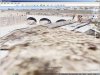
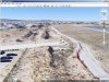
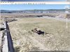
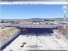
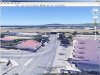
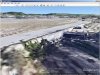
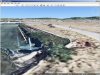
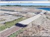
Some screenshots follow below, which are derived from examples seen in Google Earth Desktop Edition:

www.google.com
https://www.fsdeveloper.com/forum/attachments/reggio-calabria-airport-zip.57006/
After installing Google Earth, and downloading the
Reggio Calabria Airport.zip file linked immediately above, un-ZIP the archived
*.KMZ file, then double-click it; allow it to load in Google Earth.

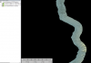
Here is how detailed such a LiDAR data set can be for your project location:
 FYI
FYI: There is 1-Meter-between-elevation-data-points LiDAR source data available for this area.

AFAIK, both a DSM and DTM version of this data set is available.
DSM LAST LiDAR con risoluzione a terra 1 metro - Regione Calabria

geodati.gov.it
DTM LiDAR con risoluzione a terra 1 metro - Regione Calabria
Geoportale Nazionale Viewer
Geoportale Nazionale - Il Visualizzatore Cartografico consente la visualizzazione e l'utilizzo della cartografia di base nazionale. L'Italia a portata di click!

www.pcn.minambiente.it
If processed via a GIS application and compiled via SDK Resample, you can make a high resolution custom local terrain mesh, and use a triangulated sub-set of the data for a 3D model and sloped flatten that fits seamlessly together with the custom terrain mesh.
") PS
PS: If you do create a version of this scenery using 1 Meter resolution elevation data, and you want to see how much the edges of CVX vector objects can be rendered in P3D without as much aliasing, you can enable a higher resolution terrain grid independently from that provided via the internal resolution of a terrain mesh BGL either by setting P3D GUI Terrain Mesh Resolution slider to 1 Meter, or by editing parameter values in the 'active' Prepar3D.Cfg file.
I recommend P3D GUI Tessellation slider be set to a max. Right position for max. terrain rendering precision:
*
Tessellation Factor (aka "Terrain Mesh Complexity" in MSFS) at 100 %
If you wish, you can enable an even higher resolution terrain grid independently from that provided via the internal resolution of a terrain mesh BGL; this will create more closely-spaced grid vertices onto which vector objects and terrain mesh data can be displayed with less aliasing (...as a function of the FS rendering engine quad 'tile' infrastructure).
Assuming you have at least a DX-11 video card, in
Prepar3D.Cfg, you may wish to test:
[TERRAIN]
LOD_RADIUS=3.500000
TESSELLATION_FACTOR=100 ; Tessellation Factor is aka "Terrain Mesh Complexity" in MSFS2Kx
MESH_RESOLUTION=
25 ; 25 = 1.2 M, 26 = 60 cm, 27 = 30 cm, 28 = 15 cm, 29 = 7.5 cm, 30 = 3.75 cm
TEXTURE_RESOLUTION=
30
See: https://www.fsdeveloper.com/forum/threads/flattens.425495/post-633002
If you do
not have a DX-11 or DX-12 video card, and you have a problem displaying Hi-Res mesh in P3D, let us know.
Hope this helps as an initial overview of your options as you consider how to proceed with this project.
")
GaryGB