• Which the release of FS2020 we see an explosition of activity on the forun and of course we are very happy to see this. But having all questions about FS2020 in one forum becomes a bit messy. So therefore we would like to ask you all to use the following guidelines when posting your questions:

    • Tag FS2020 specific questions with the MSFS2020 tag.
    • Questions about making 3D assets can be posted in the 3D asset design forum. Either post them in the subforum of the modelling tool you use or in the general forum if they are general.
    • Questions about aircraft design can be posted in the Aircraft design forum
    • Questions about airport design can be posted in the FS2020 airport design forum. Once airport development tools have been updated for FS2020 you can post tool speciifc questions in the subforums of those tools as well of course.
    • Questions about terrain design can be posted in the FS2020 terrain design forum.
    • Questions about SimConnect can be posted in the SimConnect forum.

    Any other question that is not specific to an aspect of development or tool can be posted in the General chat forum.

    By following these guidelines we make sure that the forums remain easy to read for everybody and also that the right people can find your post to answer it.

P3D v4 Ground Poly Offset

Messages
1,269
Country
us-northcarolina
Gents,

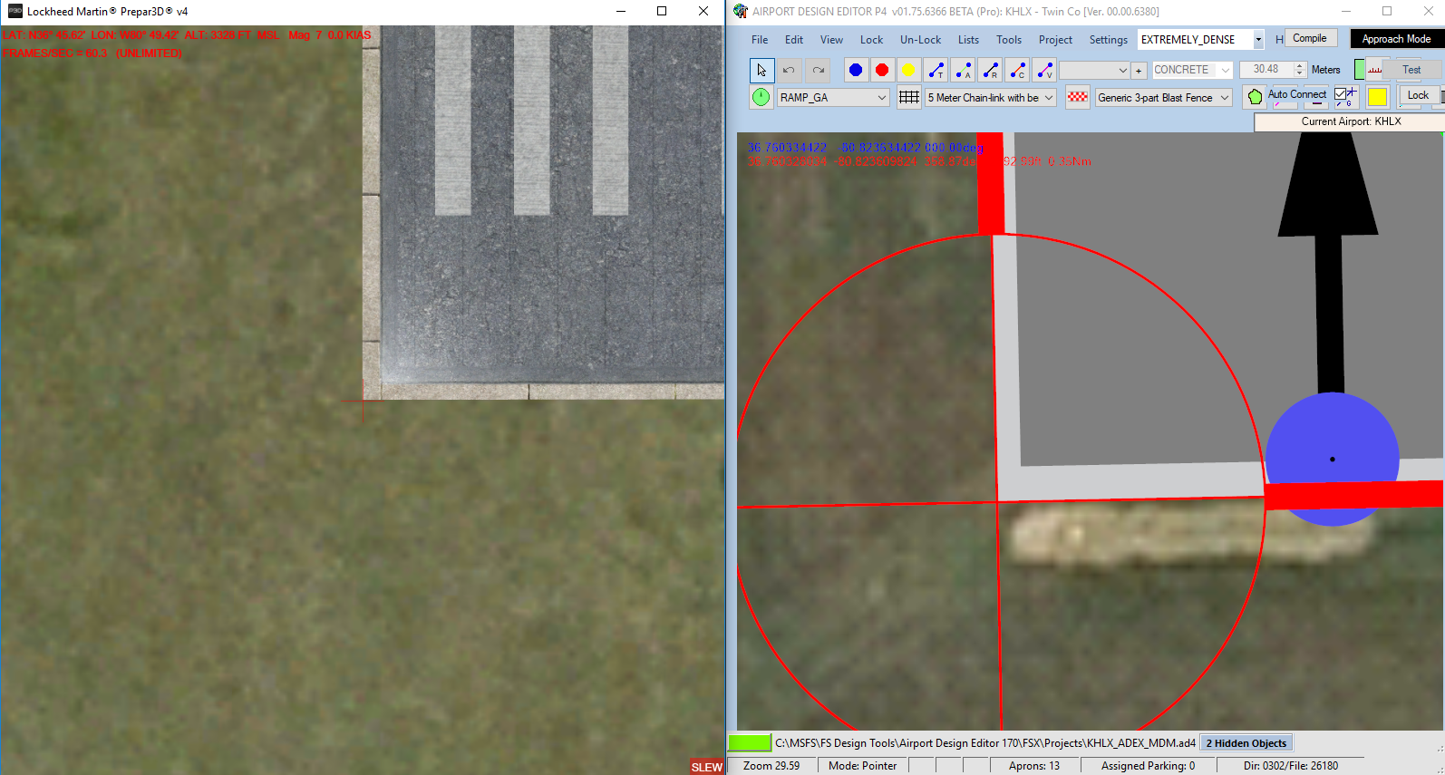
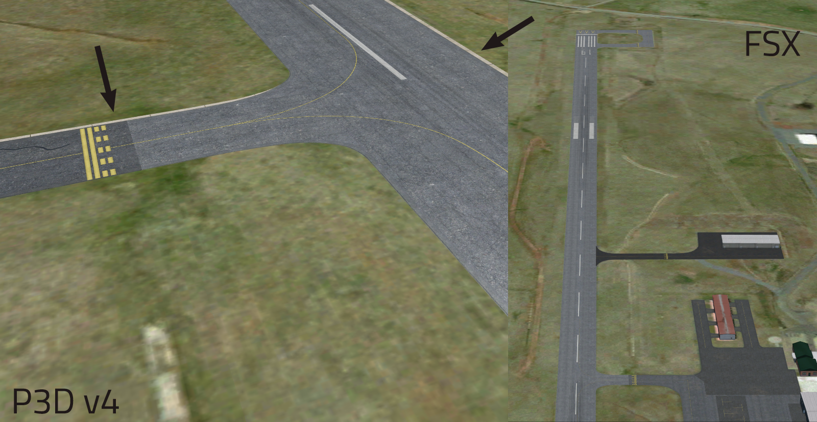
Converting some current work from FSX to P3D. Using the same Afcad file and Ground poly coordinates, I am for some reason noticing that in P3D the poly seems to be offset. This happens regardless of whether the "Optimize Reference Point" box is checked or not. Everything appears to be offset by about 3-5 feet northeast-ish.

Anybody else having this same issue or is it a known P3D bug?

Untitled-1.png


Thanks.
 

arno

Administrator
Staff member
FSDevConf team
Resource contributor
Messages
32,883
Country
netherlands
Do you use the same bgl in both or did you recompile in the GPW?

Although I don't see how that should matter, since the round earth correction is the same.
 
Messages
793
Country
us-northcarolina
Just to add, when putting the FSX version directly into P3D, it isn't offset. It becomes shifted only after applying the z-bias settings per the P3D SDK. The shift is present in both V3 and V4.
 

arno

Administrator
Staff member
FSDevConf team
Resource contributor
Messages
32,883
Country
netherlands
Are you using the latest MCX build? I fixed a bug last week that could cause an upwards shift of the polygons.
 
Messages
793
Country
us-northcarolina
I don't think we are actually. We will update and try again. If by upward you mean vertically though, we aren't seeing any of that, rather it's being shifted to the side.
 

arno

Administrator
Staff member
FSDevConf team
Resource contributor
Messages
32,883
Country
netherlands
I have no clue why it would be shifted. Are you comparing with photo scenery or the ADE airport?
 
Messages
1,269
Country
us-northcarolina
Exporting with the latest MCX release does not fix it. I am comparing it with the ADE airport. I have traced the ground poly using ADE/SimConnect in FSX to prevent any overlap, and it works perfectly in FSX. Export the same .x to P3D using the same coordinates and same ADE file results in a poly shift.
 

arno

Administrator
Staff member
FSDevConf team
Resource contributor
Messages
32,883
Country
netherlands
Maybe you can check which of the two shifted by measuring some coordinates in P3D?
 

arno

Administrator
Staff member
FSDevConf team
Resource contributor
Messages
32,883
Country
netherlands
If you measure the same GP corner in FSX you get a different coordinate you mean?

Especially if this also happens with the same BGL file loaded, it seems to indicate the P3D does some changing to the polygons before rendering...
 
Messages
1,269
Country
us-northcarolina
The position for the bottom left corner of the hard surface in ADE matches the corner of the hard surface in P3D. The concrete apron is just being used to make the surface hard beneath the GP, not for any decorative purposes. Normally, the GP will cover it completely.

Unfortunately, the coordinates of P3D aren't precise enough to let me make a direct comparison, but using the coordinates within ADE/SimConnect, it is obvious that it doesn't match. If I recall correctly, @jonmkj was saying that this had occurred at another airport in development as well.

Edit 1: After posting, I understand what you were actually asking. Here are the actual coordinates of the southwestern corner of the GP runway. Not "exact" but about as close as you can ask for.

FSX: 36.760326657 -80.823611509
P34: 36.760334871 -80.823600967

Est. Difference: -0.00000821399 -0.000010542

Using this convertor, it tells me that it shifted about 4.29 feet at a direction of 314.264°.

I disagree with the direction given since it is clearly shifted north-east not north-west from FSX to P34, however I do believe the distance looks quite reasonable. In addition, this shift seems reasonable for the entire GP, which leads me to believe that there is not any stretching/shrinking of the poly.

Edit 2: I decided to apply those corrections to the GP reference coordinate to see if I could shift it just enough. to make it work but just realized that I had missed a decimal place somewhere. Gotta run for now, but I will make the correct shift later tonight and give an update.
 
Last edited:
Messages
1,269
Country
us-northcarolina
Update.

Did the math correctly and offset the GP ref point by those values listed above. Everything seems to be aligned properly. I'm content with this workaround for now, but am certainly curious to see if it occurs for all P3x GP's and, if so, by how much.
 
Messages
793
Country
us-northcarolina
We figured it out! Not sure why, but disabling DRAW CALL BATCHING solves the problem, and a heap of other issues as well!
 

arno

Administrator
Staff member
FSDevConf team
Resource contributor
Messages
32,883
Country
netherlands
Ah, that's something I could implement in the GPW. For ground polygons I doubt the batching has much effect anyway.
 
Messages
793
Country
us-northcarolina
I read that it's a known bug with draw call batching to offset objects at higher altitude, in this case over 2,300 ft elevation. Turning it off in MCX settings solved that and some other issues we've had such as flickering and transparency problems.
 

arno

Administrator
Staff member
FSDevConf team
Resource contributor
Messages
32,883
Country
netherlands
Yes, now that you mention it. I wasn't aware that your airport was at higher altitude.
 
Messages
793
Country
us-northcarolina
another benefit of disabling DCB is that we don't have to use the alpha testing on our fences that make them shimmer and disappear in the distance. We're fairly efficient in the way we model and try to build everything into one scene.

Also Arno, we placed our grass as six different types of model over and over on the airport. I know MCX can build a scene from multiple BGLs but is there a way to take all of those individually placed MDLs and combine them into one?
 

tgibson

Resource contributor
Messages
11,338
Country
us-california
Hi,

Wouldn't it be more efficient to create the MDL files as library objects and place the *same* MDL file over and over again?
 
Messages
793
Country
us-northcarolina
Well, that's how we did it... am I wrong in thinking it would be more efficient for the simulator to handle one big object rather than a hundred of them?
 
Top