• Which the release of FS2020 we see an explosition of activity on the forun and of course we are very happy to see this. But having all questions about FS2020 in one forum becomes a bit messy. So therefore we would like to ask you all to use the following guidelines when posting your questions:

    • Tag FS2020 specific questions with the MSFS2020 tag.
    • Questions about making 3D assets can be posted in the 3D asset design forum. Either post them in the subforum of the modelling tool you use or in the general forum if they are general.
    • Questions about aircraft design can be posted in the Aircraft design forum
    • Questions about airport design can be posted in the FS2020 airport design forum. Once airport development tools have been updated for FS2020 you can post tool speciifc questions in the subforums of those tools as well of course.
    • Questions about terrain design can be posted in the FS2020 terrain design forum.
    • Questions about SimConnect can be posted in the SimConnect forum.

    Any other question that is not specific to an aspect of development or tool can be posted in the General chat forum.

    By following these guidelines we make sure that the forums remain easy to read for everybody and also that the right people can find your post to answer it.

Landclass Visibility Problem

Messages
2,192
Country
germany
Hello

A collegue of mine contacted me with the following problem, for which I do not have sufficient experience to offer him help.

Maybe someone here recognizes the problem.

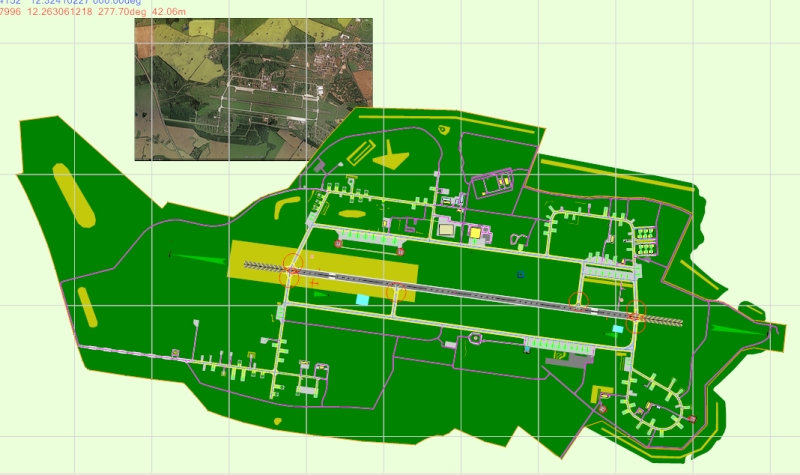
ADE was used to create the airport ETNL (Rostock Laage)

ETNL2.jpg


It contains many landclass polygons with closely spaced vertices to achieve smooth edges.
It contains also several Flatten when generating ramparts around parking areas.

Now there is a strange problem.

The project compiles properly and is activated on top priority in FSX Addon Scenery folder.
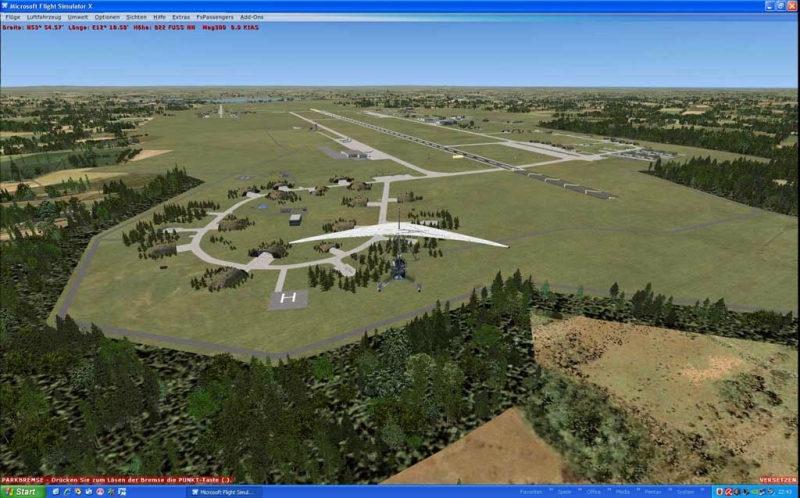
When the airport is loaded the first time after a new start of FSX, the landclass polygons are displayed only partially.

Uwe1.jpg


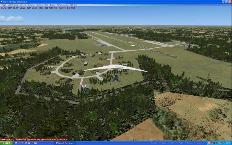
This problem does not occur when FSX is started with Stock- ETNL and subsequent activation of the ADE-ETNL in the Scenery Library.

Uwe2.jpg


Another "remedy" is to change in "Settings => display => Scenery" the Mesh Complexity slider (independent in which direction, any change will do), while FSX is running with ADE-ETNL.

Any opinion or help is highly appreciated.

Helli Hauck
 
Last edited:
Helli

I use what I call a 4 part process. Many may do it differently but I look for consistency so my 4 part process works for all airports.

First part is to look at the original Airport from above so I can see what FSX did to the airport. Notice the green ground around each runway (brown color in the winter) that FSX calls the airport background or Mask Class Map. I want to get rid of that.

fsclt01.jpg


Second part is to add a poly Exclude to the FSX default airport with ADE. I overlay a bounding box and select

Type: Exclude Specific
Tag: Airport Backgrounds Flatten MaskClassMap Autogen

This is going to do 3 things.

1. Remove the flatten
2. Remove the Airport Background (Mask Class Map)
3. Remove any Autogen that is part of the actual airport.

If you use the Type: Exclude General and the Tag: Airport Backgrounds or Everything you must be very careful drawing the exclude. If it is too large or goes outside the bounds of the stock airport background this can cause other parts of the scenery to be deleted.

clt0.jpg


VERY IMPORTANT NOTE

The above picture shows a single shape polygon exclude in the center of the airport. This is all that is required for this airport as per the SDK since the stock Mask Class Map is a single shape within a QMID cell. See next picture.


PLEASE NOTE: many stock airports have multiple shapes that make up the airport background and a single polygon exclude will not work. At the end of this 4 step tutorial I show examples of airports that have multiple shape sections and explain how to exclude all of the airport background.

Once the exclude is in place I look at FSX/Airport from above. You can now see that the original Mask Class Map is gone.

clt1.jpg


If I go to ground level you can see that the flatten is gone, the Mask Class is gone and all the default FSX autogen is all over the place. That is expected since I excluded everything which causes all the default autogen to pop back up.

fsclt04.jpg


The third part is to draw the Mask Class Map the way I want it to look based on pictures and Google Earth. As I draw the Mask Class I am also creating the flatten and the tag that says exclude the default autogen. I added the new 3rd parallel runway for this airport and new roads.

clt2.jpg


If I go to top down view I can see my new airport background.

fsclt06.jpg


I look at the Airport in top down view and everything is showing the way I drew it BUT, I do not like what is surrounding the airport. As per Google Earth there are different types of scenery around the airport that is different then what FSX shows.

Forth Step, I start out and draw different polys around the airport background Mask Class Map.

IMPORTANT, a few poly land classes such as cement can lay on top the Mask Class Map but most cannot. If I place a poly land class on top of the Mask Class Map this can confuse what FSX will actually show.

I added a Park but butted up to the Mask Class Map keeping the overlap to a minimum.

fsclt07.jpg


I added some dirt at the threshold of the runway on the right. That type poly land class can overlay on top of the Mask Class Map.

fsclt08.jpg


Between the runways on the left I want a poly that looks like the Mask Class Map but I want to keep the swells and ditches in place. To do this I used a Airfield1 poly

fsclt09.jpg


Now I also add some more trees (City Park land class) along the bottom of the airport and the entrance way to the Cargo Area.

fsclt010.jpeg


I look at my original FSX airport which looked this way
.
.
fsclt01.jpg


After reworking the Airport it now looks like this.
.
.

.

How to exclude multiple section Mask Class Map backgrounds

In step 2 (second part) of this tutorial I excluded a single shape airport background by placing a polygon exclude in the center of the airport. However as we will see many airport backgrounds can have multiple shapes and together they make up the Mask Class Map background.

Using both the SDK TMFviewer and ADE the following pictures are 2 examples of airports that have multiple shapes. This airport has 6 different shapes that must be excluded. I want the polygon excludes (cyan color) to overlap as many sections of the background so a minimum of excludes are used. I add the exclude down the center of the long runway and that will exclude 4 of the airport backgrounds. I can now remove the remaining 2 backgrounds with a carefully placed exclude in the lower left side of the airports Mask Class Map.


This example shows 9 shapes that make up the entire Mask Class Map. I need a total of 4 properly placed polygon excludes that overlap each of the bounding boxes to completely remove all the airport background.


If you do not use the TMFviewer and do not know if the airport background has multiple shapes the next picture shows how FSX uses the actual shape geometry method to remove all the Mask Class Map. You can use the boundary fence as a guide so your exclude stays inside the airports bounding boxes.


It is very important you use the exclude specific types when drawing the actual shape geometry method. This will make sure only the Mask Class Map + Flatten + Autogen is excluded within the bounds of the airport.

The small exclude bounding box method may not be as precise as the actual shape geometry method but is much faster at runtime.
 
Last edited:
Jim

thanks for another tutorial.
In case you loose it, remember that I have a copy of it, because I am sure I will need it in the near future!

Well, what you say deepens my suspicion too, that my friend's problem stems from placing polygons on top of each other in a wrong sequence.

But still, why does everything come up perfectly after forcing FSX to re-install the data over the stock data??
I guess that is, what the "remedy"-procedure of changing the settings with FSX running provokes.

Helli Hauck
 
Another "remedy" is to change in "Settings => display => Scenery" the Mesh Complexity slider (independent in which direction, any change will do), while FSX is running with ADE-ETNL.


Helli

I call that pulling up on the mesh/ground textures. Scott can explain it better but if the poly's are not correct then sliding the mesh sliders force a change in the way the ground looks.

That is telling us the poly's are corrupt (layered wrong) in some way or another.

I place all my mesh, terrain, scenery and autogen sliders to the right (max position) when placing all the poly's and drawing shape vectors. If the final scenery looks correct then sliding the sliders back to the left to a more normal position will not change the pull up of the mesh and only decrease the amount of scenery and autogen.

Sometimes the designers want to shortcut the laying of polys and do not remove the original Mask Class Map with the exclude (lay other poly's on top). My 4 step process does not shortcut the sequence and works for every type default airport using default poly GUID's.

Translate the words to German and use my post/pictures on other forums as needed. Airport is KCLT and it is my next work in progress project since WSSS Singapore is now done.
 
Last edited:
I'm not sure what is going on, but one thing to watch out for is that the landclass can change based on the slope gradient. I don't think that is a problem if you use the airport background with maskclassmap, but if you use a straight landclass you can get this. Most common is on a slope a field texture is replaced by trees.

I suppose the point where FSX computes the slope might be an issue, but I've never tried this. It is a common problem, though, that an airport has a flatten, and high resolution mesh is used so that there is a sharp dropoff at the edge of the flatten. The landclass texture change is used on that slope. The best fix is to correct the slope using sloped flattens.

scott s.
.
 
I had this problem today, and I am so happy to have found this thread on my first search! The "search" button is my friend.

This is an absolutely fantastic product, and the help is always worth-while. I always recommend this forum to fellow designers/pilots since I always find what I need.
BIG thanks to all!:D

Dave
 
A good tutorial which I have printed off.

I want to try this on a NEW airport I have done but before I blunder on will the "exclude General" "Everything" poly also exclude objects placed using Instant Scenery?

Regards
 
A good tutorial which I have printed off.

I want to try this on a NEW airport I have done but before I blunder on will the "exclude General" "Everything" poly also exclude objects placed using Instant Scenery?

Regards

If you are referring to a terrain polygon then no it will not exclude objects placed using Instant Scenery. An Exclusion Rectangle will do that however.
 
What is exactly the difference between an "Exclusion Polygon" (as in 15.2.4 of the manual) and an "Exclusion Rectangle" (manual 14.3.3)?
When you should use the one or the other?

Note: 15.2.4 says "The important thing to remember is to make sure that the exclusion intersects the perimeter of the airport background polygon". It refers to the original background or the new one? What if you need to use the exclusion for an area within the background?
 
Last edited:
An exclusion rectangle is part of the BglComp SDK and is used to exclude scenery objects types (library objects, generic buildings, windsocks, taxi signs and so on) from the area it covers. By definition they are rectangular. This is the same for FS9 and FSX.

Any Exclusion Polygon is part of the Shp2Vec Terrain SDK and applies to FSX. Similar polys can be created for FS9 but ADE does not support this as yet. This will exclude terrain elements depending on the settings including autogen. In FS9 it is possible to exclude some forms of autogen with an Exclusion Rectangle. This is not possible in FSX. By definition and Exclusion polygon is a multi sided shape.
 
Note: 15.2.4 says "The important thing to remember is to make sure that the exclusion intersects the perimeter of the airport background polygon". It refers to the original background or the new one? What if you need to use the exclusion for an area within the background?

It refers to the default background and will remove the background polygon completely.

The only reason you might wish to have an exclusion within the background polygon is to exclude scenery objects. In this case you need to use an exclusion rectangle.
 
Thnx jvile, your little tutorial made it so much easier to sort out the ground poly's. I had read the section in the manual a few times & still could quite get it.
 
Helli

I use what I call a 4 part process. Many may do it differently but I look for consistency so my 4 part process works for all airports.

First part is to look at the original Airport from above so I can see what FSX did to the airport. Notice the green ground around each runway (brown color in the winter) that FSX calls the airport background or Mask Class Map. I want to get rid of that.

View attachment 19041

Second part is to add a poly Exclude to the FSX default airport with ADE. I overlay a bounding box and select

Type: Exclude Specific
Tag: Airport Backgrounds Flatten MaskClassMap Autogen

This is going to do 3 things.

1. Remove the flatten
2. Remove the Airport Background (Mask Class Map)
3. Remove any Autogen that is part of the actual airport.

If you use the Type: Exclude General and the Tag: Airport Backgrounds or Everything you must be very careful drawing the exclude. If it is too large or goes outside the bounds of the stock airport background this can cause other parts of the scenery to be deleted.

View attachment 26779

VERY IMPORTANT NOTE

The above picture shows a single shape polygon exclude in the center of the airport. This is all that is required for this airport as per the SDK since the stock Mask Class Map is a single shape within a QMID cell. See next picture.


PLEASE NOTE: many stock airports have multiple shapes that make up the airport background and a single polygon exclude will not work. At the end of this 4 step tutorial I show examples of airports that have multiple shape sections and explain how to exclude all of the airport background.

Once the exclude is in place I look at FSX/Airport from above. You can now see that the original Mask Class Map is gone.

View attachment 26780

If I go to ground level you can see that the flatten is gone, the Mask Class is gone and all the default FSX autogen is all over the place. That is expected since I excluded everything which causes all the default autogen to pop back up.

View attachment 19044

The third part is to draw the Mask Class Map the way I want it to look based on pictures and Google Earth. As I draw the Mask Class I am also creating the flatten and the tag that says exclude the default autogen. I added the new 3rd parallel runway for this airport and new roads.

View attachment 26781

If I go to top down view I can see my new airport background.

View attachment 19046

I look at the Airport in top down view and everything is showing the way I drew it BUT, I do not like what is surrounding the airport. As per Google Earth there are different types of scenery around the airport that is different then what FSX shows.

Forth Step, I start out and draw different polys around the airport background Mask Class Map.

IMPORTANT, a few poly land classes such as cement can lay on top the Mask Class Map but most cannot. If I place a poly land class on top of the Mask Class Map this can confuse what FSX will actually show.

I added a Park but butted up to the Mask Class Map keeping the overlap to a minimum.

View attachment 19047

I added some dirt at the threshold of the runway on the right. That type poly land class can overlay on top of the Mask Class Map.

View attachment 19048

Between the runways on the left I want a poly that looks like the Mask Class Map but I want to keep the swells and ditches in place. To do this I used a Airfield1 poly

View attachment 19049

Now I also add some more trees (City Park land class) along the bottom of the airport and the entrance way to the Cargo Area.

View attachment 19050

I look at my original FSX airport which looked this way
.
.
View attachment 19041

After reworking the Airport it now looks like this.
.
.

.

How to exclude multiple section Mask Class Map backgrounds

In step 2 (second part) of this tutorial I excluded a single shape airport background by placing a polygon exclude in the center of the airport. However as we will see many airport backgrounds can have multiple shapes and together they make up the Mask Class Map background.

Using both the SDK TMFviewer and ADE the following pictures are 2 examples of airports that have multiple shapes. This airport has 6 different shapes that must be excluded. I want the polygon excludes (cyan color) to overlap as many sections of the background so a minimum of excludes are used. I add the exclude down the center of the long runway and that will exclude 4 of the airport backgrounds. I can now remove the remaining 2 backgrounds with a carefully placed exclude in the lower left side of the airports Mask Class Map.


This example shows 9 shapes that make up the entire Mask Class Map. I need a total of 4 properly placed polygon excludes that overlap each of the bounding boxes to completely remove all the airport background.


If you do not use the TMFviewer and do not know if the airport background has multiple shapes the next picture shows how FSX uses the actual shape geometry method to remove all the Mask Class Map. You can use the boundary fence as a guide so your exclude stays inside the airports bounding boxes.


It is very important you use the exclude specific types when drawing the actual shape geometry method. This will make sure only the Mask Class Map + Flatten + Autogen is excluded within the bounds of the airport.

The small exclude bounding box method may not be as precise as the actual shape geometry method but is much faster at runtime.

Hi Jim,

Good tutorial but why are several of the photos mission? There are 5 photo images mission and can't see the work you've done. It just shows a small square box with an x. Also, would you tell us what airport this is that you used in this tutorial?

Ken.
 
https://www.fsdeveloper.com/forum/threads/landclass-visibility-problem.15173/post-815106

Hi Jim,

Good tutorial but why are several of the photos mission? There are 5 photo images mission and can't see the work you've done. It just shows a small square box with an x.


Hi Ken:

Unfortunately Jim Vile had an early departure for a 'flight' a couple of years ago (R.I.P.). :oops:

AFAIK, he may now be "At play in the (air)-fields of The Lord". ;)

I believe I have made a copy of his posts in this thread with intact image attachments via a FireFox feature:

FireFox Menu > File > Save Page As > Web page, complete (*.htm; *.html).


If I can, I will post either a 'restored quote', or a ZIP copy of the *.htm and attached *._files subfolder of images etc. which can be opened as a normal 'offline' web page in a web browser ...either tonight or tomorrow (Sunday). :)

https://www.fsdeveloper.com/forum/threads/landclass-visibility-problem.15173/post-815106
Also, would you tell us what airport this is that you used in this tutorial?

Ken.

PS: Jim mentioned the airport in-context farther down in this thread:

https://www.fsdeveloper.com/forum/threads/landclass-visibility-problem.15173/post-97840

Airport is KCLT and it is my next work in progress project since WSSS Singapore is now done.

GaryGB
 
Last edited:
Hi Ken:

Unfortunately Jim Vile had an early departure for a 'flight' a couple of years ago (R.I.P.). :-(

AFAIK, he may now be "At play in the (air)-fields of The Lord". ;-)

I believe I have made a copy of his posts in this thread with intact image attachments via a FireFox feature to 'Save as > Web page (Complete).

If I can, I will post a ZIP copy of the *.htm and attached *._files subfolder of images etc. which can be opened as a normal 'offline' web page in a web browser ...either tonight or tomorrow (Sunday). ;-)


PS: Jim mentioned the airport in-context farther down in this thread:


GaryGB


Okay, Thanks.
 
Back
Top