• Which the release of FS2020 we see an explosition of activity on the forun and of course we are very happy to see this. But having all questions about FS2020 in one forum becomes a bit messy. So therefore we would like to ask you all to use the following guidelines when posting your questions:

    • Tag FS2020 specific questions with the MSFS2020 tag.
    • Questions about making 3D assets can be posted in the 3D asset design forum. Either post them in the subforum of the modelling tool you use or in the general forum if they are general.
    • Questions about aircraft design can be posted in the Aircraft design forum
    • Questions about airport design can be posted in the FS2020 airport design forum. Once airport development tools have been updated for FS2020 you can post tool speciifc questions in the subforums of those tools as well of course.
    • Questions about terrain design can be posted in the FS2020 terrain design forum.
    • Questions about SimConnect can be posted in the SimConnect forum.

    Any other question that is not specific to an aspect of development or tool can be posted in the General chat forum.

    By following these guidelines we make sure that the forums remain easy to read for everybody and also that the right people can find your post to answer it.

FSX Raising Terrain on FSX

Messages
9
Country
canada
I’m going nuts with the terrain elevation on FSX:mad:, please, can anyone help me???

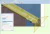
I created a Dike with Google Sketchup, converted and Add it to FSX. Everinth Ok until now...

But, as you can see in the pic...Both edges of the dike are higher then the terrain, what does it look ugly.

How can I raise the terrain to match the height of the dike???

I try to use the ADE and SBuider, but without success..

I try to find a tutorial....nothing...Maybe an expert could make one tutorial about this matter!!??

Very thanks
 

Attachments

  • dike.jpg
    dike.jpg
    357.3 KB · Views: 535
as Stiz suggested, ADE offers a nice utility for making flattens, both parallel and slanted, that would help you fit your ground to your object.
 
Thanks STIZ and thanks bob5568...

Like I said I used ADE without success...

Maybe I do not know how to use ADE properly because I’m not an expert...But,please, take a look on the pic to
see what I did.

I created a Terrain polygon to flatten the ground and I made a check mark on “Edit Individual Points”.
Compiled it and add the BGL to FSX...and guess what...That’s right...nothing happens. The terrain remains the same.

Probably I’m doing something wrong, but I can’t know what...

If anyone knows what are the right precisions to do the work, please explain me... I really appreciate it.

Very thanks.
 

Attachments

  • Dike-ADE.jpg
    Dike-ADE.jpg
    262.9 KB · Views: 557
There are 2 BGL files created - did you copy both of them to the active scenery folder?
 
I don't understand your pic. It appears as though runway 29 is surrounded by water :eek:

In fact, the default airport is positioned too far to the north. The only water is to the south-west.

 
Last edited:
hi...GHD,

It Isn’t A Rwy...It is a dike or dyke :
-------------------------------------------------------------------------------------------
Dyke
From Wikipedia, the free encyclopedia
(Redirected from Dike)
Jump to: navigation, search
Look up dike or dyke in Wiktionary, the free dictionary.

Dyke or dike may refer to:

A natural or artificial slope or wall to regulate water levels, called levee in American English.
------------------------------------------------------------------------------------------

Anyway, if you know how to raise the Terrain on each side of the dike (dyke), I really appreciate it.

Very thanks..
 
oddly you are doing it right, assuming you chose altitudes higher than the current ground. You must not be compiling the bgl correctly (I can't imagine how, as this is easy), or not adding your bgl to your scenery folder?
 
Anyway, if you know how to raise the Terrain on each side of the dike (dyke), I really appreciate it.

OK. Are you using the default mesh?

Post the coords of the dyke and I'll see what I can do.
 
I'm afraid you have a big problem.

The land and water behind your dam needs raising to the top of your model:


Unfortunately you will need to exclude the default hydro-poly which will remove it to the surrounding QMid11 rectangle. You will then need to define at least two new hydro-polys, one at sea-level to replace what you have excluded and one at the reservoir height:


ADE is not the appropriate tool for this, it would be better to SBuilderX
 
GHD...Thanks....

I think it is a little more difficult than I thought and maybe is above of my knowledge.

There is a possibility that you can make a small tutorial here or send it to me: Linopor@hotmail.com ,or if you know some place where I can find anything about how to raising the terrain? I really appreciate it.

Thanks very much
 
I’m almost there...Thank you guys!
Gibson...You were right...A _CVX.bgl. was missing in my active scenery folder.
Now that is there, I make a POLY/AIRPORT BACKGROUND/FLATTEN EXCLUDE AUTOGEN, and the result was this pic...take a look.
I have a small problem with a water that goes up on the terrain, but I think it is only a question of time and I will fix it.
Once more, thank you very much for the time you spend whit this matter.
I’ll keep in touch....
Thanks
PS: But if you guys have any different ways to do it please keep post it .
 

Attachments

  • LPPM-Dam.jpg
    LPPM-Dam.jpg
    238 KB · Views: 417
Yes, this technique is a problem at dams, since the maximum slope of the water is limited to the position of the existing elevation points. You can create some local mesh yourself that will improve that, but that's another program to learn...
 
Back
Top