• Which the release of FS2020 we see an explosition of activity on the forun and of course we are very happy to see this. But having all questions about FS2020 in one forum becomes a bit messy. So therefore we would like to ask you all to use the following guidelines when posting your questions:

    • Tag FS2020 specific questions with the MSFS2020 tag.
    • Questions about making 3D assets can be posted in the 3D asset design forum. Either post them in the subforum of the modelling tool you use or in the general forum if they are general.
    • Questions about aircraft design can be posted in the Aircraft design forum
    • Questions about airport design can be posted in the FS2020 airport design forum. Once airport development tools have been updated for FS2020 you can post tool speciifc questions in the subforums of those tools as well of course.
    • Questions about terrain design can be posted in the FS2020 terrain design forum.
    • Questions about SimConnect can be posted in the SimConnect forum.

    Any other question that is not specific to an aspect of development or tool can be posted in the General chat forum.

    By following these guidelines we make sure that the forums remain easy to read for everybody and also that the right people can find your post to answer it.

Sloped ground polygon ?

Messages
283
Country
france
Hello !

So i wanted to make a sloped ground poly for some reason (The runway is actually sloped on the real field and i can't make a flatten that's look correct because of some global addons - France VFR- who include their own mesh)

mooq.jpg


ml9v.jpg


Is it even possible to make some sloped GP's or do i miss something ?

Thanks !
 
Nope. Ground polygons are as flat as it gets. Either you flatten the slope feature locally (and minimally), or you would have to create a sloped platform with a custom ground texture.

David
 
Theses are some « simple » polygon, like flatten or landclass...

you can’t place some «true » sloped ground poly with SbuilderX (But it would be easier than with MCX and the latitude/longitude !)
 
IMHO, what is most important is deciding whether you are trying to utilize Material Properties when the mapped aerial or satellite ground texture image is displayed in FS at run time.

In the example Fayence-Tourrettes_Airfield shown above, the area of the airport name is grass, so you would be less likely to have much use for a flat 3D model in:

* non-MDL format SCASM / ASM-compiled (with very limited Material Properties)

...or in:

* MDL format XtoMDL-compiled (with more Material Properties than SCASM / ASM G-Polys)

...instead of terrain-mesh-clinging default or custom land class implemented via sloped terrain polygons compiled with SDK SHP2VEC or SDK Resample.

Alternatively, one could utilize textured legacy format LWM3 sloped polygons.

All of the latter non-3D model terrain polygon methods cited above could yield a high resolution "decal" image of the Fayence-Tourrettes_Airfield ground logo draped as mesh-clinging objects onto any underlying terrain mesh without using a flatten.

FYI: Flat 3D model Ground polygons (aka "G-Polys") most commonly are only used when you are trying to utilize Material Properties to show environmental lighting and precipitation effects etc. for paved areas ...when the mapped aerial or satellite ground texture image is displayed in FS at run time. ;)

GaryGB
 
Last edited:
Hello Gary !

So if I understood well, you are saying that for this kind of airfield (Grass) it’s way better looking to use the « Classic » ground texture instead of some « flat 3D models » for the ground texture. (correct me if i am wrong, that was actually a lot of complex things for my poor English ....)

I made this Ground mark as a 3D model because it was actually made of concrete in real life, so it is clearly looking way better with this and it’s too less « blurred » than a classic ground texture who we usually set up to 1m/pixel in order to don’t affect too much the loading time, so if I included it in my photorealistic tiles it would be kinda ugly !

Thank you,

Alexandre
 
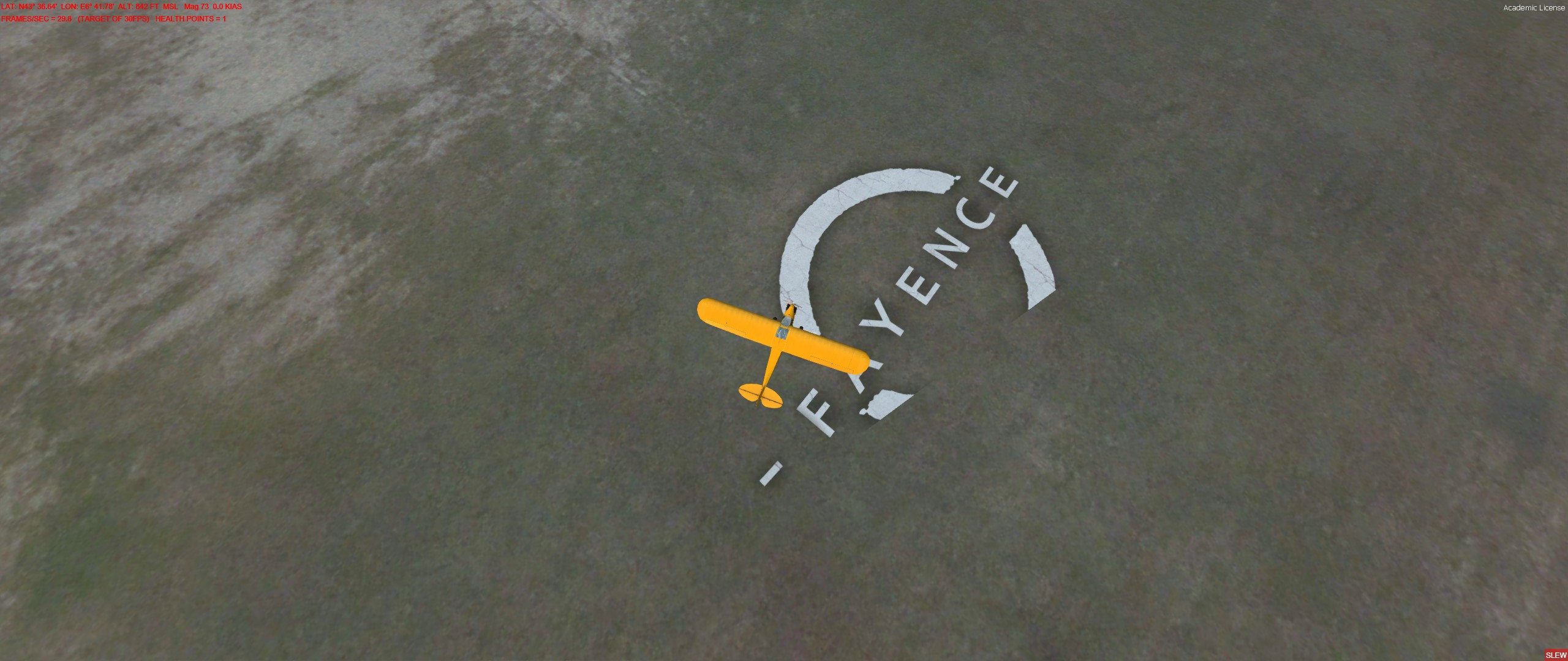
Certainly if the Fayence-Tourrettes_Airfield area of the airport name is concrete, you would likely have a good use for a flat 3D model in:

* non-MDL format SCASM / ASM-compiled format (with very limited Material Properties)

...or in:

* MDL format displayed with Material Properties


If the FS target version for this scenery is P3Dv4.x you could further enhance the display of the Fayence-Tourrettes_Airfield airport name concrete object by creating it as a MDL-based P3Dv4.x SDK-compliant G-Poly which implements the Z-Bias Material Property. :idea:

Your sloped CVX vector flatten polygon could be placed under the area of the Fayence-Tourrettes_Airfield airport name concrete object so that there would be no issues with flickering (aka "Z-Buffer Fighting").

This would best best achieved, IMHO, by modeling both the airport flatten polygon surface area and the flat 3D model of the G-Poly object in the same project of your 3D modeling program so that they are exactly in alignment with each other.

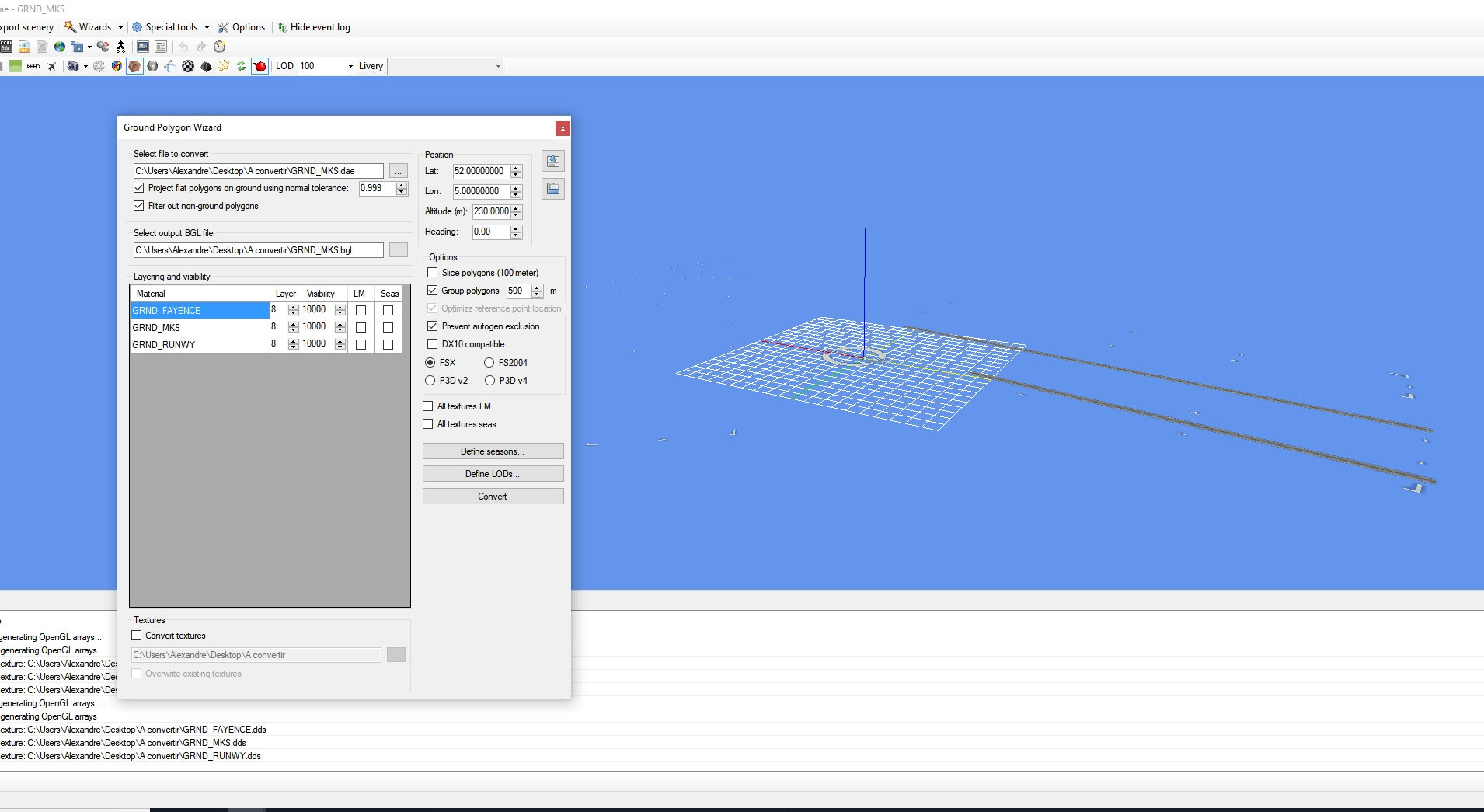
Then, separately export those objects and import them into Arno's ModelConverterX (aka "MCX").

The airport (sloped) flatten polygon surface can be exported by MCX as a "FSX flatten BGL file (*.BGL)"

The flat (sloped) 3D model of the G-Poly object can be imported via the MCX Ground Poly Wizard but requires special procedures to assign unique elevations to the corner vertices before export as a MDL, so that it will not be arbitrarily aligned by MCX to a horizontal plane (instead of retaining the slope assigned in the 3D modeling application before it was imported to MCX).

Perhaps Arno might offer some suggestions on how one may achieve this within MCX and/or MCX G-Poly Wizard for a sloped G-Poly (...while still allowing use of Material Properties and tweaks to the Z-Bias parameter as well as parameters for precipitation effects etc.) ? :scratchch

Alternatively, if one disables Draw Call Batching of textures mapped on the G-Poly MDL during export from MCX, one may simply place the G-Poly as a BGLComp XML-type scenery library object using the 'Pitch' and 'Bank' placement options (...which are otherwise automatically disabled by Draw Call Batching of textures mapped on the MDL during export from MCX).


Prepar3D SimDirector, Whisplacer, Instant Scenery etc. may all be used to fine-tune BGLComp library object placement and alignment of a MDL-based (sloped) flat 3D G-Poly object with an underlying terrain flatten surface inside a FS flight.

Regarding the BGLCompiler 'Pitch' and 'Bank' placement options:

http://www.prepar3d.com/SDKv4/sdk/world/scenery/scenery_overview.html#XML Format

GaryGB
 
Last edited:
But what does it change if the classification of the field is concrete or Grass ?

I’m not really sure to understand the whole thing, I just did some search about the Z-Bias Material Property, what it is ?
 
It is not 'required' for a G-Poly made via the MDL method to utilize 'custom' Material Properties and tweaks to the Z-Bias parameter as well as parameters for precipitation effects etc., but most FS developers appear to implement those options to minimize flickering, ground shadow anomalies, and so that "concrete" looks more realistic as lighting and weather changes ex: when it rains in FS (aka "precipitation effects").


Z-Bias Material Properties are applied to 3D models output as MDLs ...as implemented by Prepar3d SDK:

https://www.google.com/search?source=hp&ei=1SWHW8_wGtDatQXp2KcI&q=site:www.fsdeveloper.com+P3D+Prepar3d+Material+Properties+Z-Bias+&oq=site:www.fsdeveloper.com+P3D+Prepar3d+Material+Properties+Z-Bias+&gs_l=psy-ab.12...12462.62257.0.67082.53.52.1.0.0.0.151.3938.48j4.52.0....0...1c.1.64.psy-ab..0.5.505...0j0i131k1.0.qSslDqprJ14

GaryGB
 
Last edited:
Okay, thank you very much for all of thoses explains,I will take care of this for my future projects !
MCX is a really awesome soft, the way that you explained (Creating the gp based on the flatten) is theoretically good, but everyone isn’t using the same tierce addons so it’s not a « Universal » way to do it ... I think ?
 
https://www.fsdeveloper.com/forum/threads/sloped-ground-polygon.443521/post-805328

Okay, thank you very much for all of those explanations, I will take care of this for my future projects !

MCX is a really awesome software, the way that you explained (...creating the G-Poly based on the flatten) is theoretically good, but everyone isn’t using the same <tierce> (3rd party) addons so it’s not a « Universal » way to do it ... I think ?

A CVX vector flatten polygon BGL (whether it is sloped or perfectly horizontal over its entire surface) will take total control over any elevation data points otherwise displayed by a underlying terrain mesh BGL.

Thus, if you make a sloped CVX vector flatten polygon BGL for the area of the Fayence-Tourrettes_Airfield airport name concrete object, it will forcibly take control of any default or 3rd party terrain mesh and it will instead have the shape you have assigned.

So, if you configure the G-Poly object Poly (...with Draw Call Batching disabled in MCX before export as a MDL! ) to match the slope of the (sloped) flatten using Pitch and Bank parameters via the proper XML elements when you place the G- via a BGLComp XML-type placement BGL, it should be aligned perfectly parallel with the surface of the ground imposed by that sloped flatten. ;)

Then all you would need to do is adjust the 'absolute' elevation (aka "altitude" AMSL) of the super-imposed G-Poly so it is either at the same- or slightly above- the surface elevation of that (sloped) flatten. :pushpin:


PS: Since the central datum (aka "Reference Point" or "RefPoint") of the flat 3D G-Poly will be used to determine the 'absolute' elevation (aka "altitude" AMSL) position of the G-Poly when it is placed via a BGLComp XML-type placement BGL, that G-Poly object should be aligned in the 3D modeling application so that its center is exactly on the Origin of 3D world axes.


FYI: IIRC, it is possible to do this 'object centering' in a MCX development version, but I do not recall where that is applied in the MCX GUI.

Instead, I do this in Sketchup using rhumbaflappy's plugin Ruby script "Center_Group_Bottom": :idea:

https://www.fsdeveloper.com/forum/threads/centering-objects.71321/

GaryGB
 
Last edited:
Nice, thank you for that, i’ll Try to flatten the field without bother the average area,
 
https://www.fsdeveloper.com/forum/threads/sloped-ground-polygon.443521/post-805356

Nice, thank you for that, i’ll Try to flatten the field without bother the average area,

Indeed, most developers would likely flatten (to the horizontal plane) all areas of the airfield which require AI traffic to operate normally, and also to make it easier to use G-Polys with Material Properties without having them "sloped".

The edge of the airfield could otherwise be blended into the gradually sloping terrain mesh uphill to the North just beyond the area of the of the Fayence-Tourrettes_Airfield ground logo by use of a custom sloped CVX vector airport background flatten BGL created in ex: Sketchup and imported to MCX for export as a "FSX flatten BGL file (*.BGL)". ;-)

GaryGB
 
Last edited:
That exactly what i tried to do but i seems to have another problem, i attached 2 files : the Flatten who cover the whole airfield in order to make it completly flat, and the slope who create some slopes (obviously ...) arround the flatten to not create some cliffs.

It's working well for the East and West part of the airfield, but, surprisely i still have 2 cliffs at the north and at the south :

North :
1535636790-2018-8-30-14-32-13-164.jpg

South :
1535636852-2018-8-30-14-32-24-397.jpg


Otherwise it's working well :

1535636790-2018-8-30-14-32-36-328.jpg


I have to say too that on the default scenery it's working with only the flatten, here i'm trying to make the scenery compatible with a "France VFR" product who include an highly detailled mesh (And some phototiles).

Any ideas ?
 

Attachments

Classic! Did you make the flatten polys square shape? If you did......don't. They need to be a mesh of multiple flatten triangles. So if you had for example, a big square....divide it into two or more triangles. Eeach vertex should have it's appropriate elevation i.e., adjacent vertex elevation should match. The smaller the triangles....the better the resolution but the more burden on the FS elevation processor.
 
A quick inspection of the above attached files in SDK TMFViewer shows that triangles were not used in constructing the central airport "horizontal" flatten and the "sloped" flatten to blend into surrounding terrain.


More details may be discerned on Altitude and/or Slope assigned to the CVX vector scenery objects in question by de-compiling those BGL files in Patrick Germain's CVXExtractor with output of ESRI Shape (aka "*.SHP") files:

http://www.fsdeveloper.com/forum/threads/cvxextractor-exporting-vector-data.432918/


...then 'Appending' all resulting ESRI *.SHP files to a new (empty) project in SBuilderX version 3.15.

https://www.fsdeveloper.com/forum/threads/sbuilderx-v315.441705/


I recommend downloading / using rhumbaflappy's ZIP packaged install: Full SbuilderX v315


Select / Right-click vector polygons in SBuilderX to see / edit assigned Altitude / Slope values on the "Properties" dialog [General] tab.


FYI: Use of the SBuilderX Line and/or Polygon tools modes will allow implementing triangles. :pushpin:

GaryGB
 
Well, i used SBuilderX to made thoses two bgl’s but yup, pinkjr I didn’t made some triangles at all, i’ll try to do it manually, like I will create by myself some triangles (so It’s actually working exactly like a 3D model).
Thank’s !
 
It worked, thank you again !

We are coming out of the slope subject but i have an autogen exclusion arround the airfield that appear only with tierces addons like here with the same France VFR scenery whith its autogen :

2018-8-30_17-52-34-552.jpg


The flattens that i just created shouldn't be responsible and nothing that i made by myself come this far away, i took care to prevent autogen exclusion on the biggests ground poly, i really have no idea why i see this ...
Could you help me ... again ?!
 
Back
Top