Hello:
It's good to see even more features implemented into ADE with each new release, and I greatly appreciate the efforts made to improve accuracy in placement of objects relative to a correctly projected Geo-rectified background image in ADE as well.
Although my own personal preference for a higher degree of precision in placement of content for FS may not be shared by all FS Developers here, I believe it might be helpful (for purposes of considering options for possible code revision in the future), to post a link to some interesting details of what the interconversion formulas reportedly are for "The Google Maps / Bing Maps Spherical Mercator Projection" and WGS84:
"
Firstly, you should start by making sure that you’re supplying the correct EPSG code, 3857, and that it corresponds to the projection parameters listed above.
However, unless you’re using a conversion library that has been specifically designed to handle the special case of the Bing Maps / Google Maps projection, you’re also going to have to provide a little bit more information to explain that the projection should occur from the sphere rather than the WGS84 ellipsoid specified in the geographic coordinates system. That additional information can be supplied in different ways":
http://alastaira.wordpress.com/2011/01/23/the-google-maps-bing-maps-spherical-mercator-projection/
Hopefully this information might someday prove helpful to solving some baffling misalignment scenarios FS Developers might encounter.
AFAIK, such formulas haven't (yet) addressed what further corrections are required as a function of the "Z" coordinate (aka
elevation above the surface of the Earth relative to a WGS84 terrain model), which adds another element of complexity to accurate computation of FS quad matrix grid coordinates (and
3D "shape" of FS quads) ...for those 'pushing the envelope' with pioneering efforts to implement FS flights between objects placed in low earth orbit at- or close to- the 100,000,000 feet of max elevation actually navigable in the FSX 3D world model:
[
EDITED]
"
The maximum altitude in the game has been increased to 100,000,000 ft (30,480,000 Meters or 18,939.393939 statute miles). Therefore, FSX maximum altitude is approximately 2.39 times the diameter of the Earth at the equator."
http://en.wikipedia.org/wiki/Microsoft_Flight_Simulator_X
NOTE: The international Space Station (aka "ISS") is maintained at an orbital altitude of between 330 km (205.052 statute mi) and 435 km (270.296 statute miles)
https://en.wikipedia.org/wiki/International_Space_Station
Some related links:
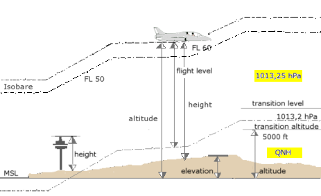
http://en.wikipedia.org/wiki/Geodesy#Heights
http://en.wikipedia.org/wiki/Altitude#Altitude_in_aviation
http://en.wikipedia.org/wiki/Transition_altitude#Transition_altitude
http://en.wikipedia.org/wiki/Elevation
http://en.wikipedia.org/wiki/Equatorial_bulge
BTW: Please forgive the brief slightly divergent topical sideline in the context of this thread, but this recent series of thread postings brought to mind some of the concerns that FSX "Aerospace" involves as far as 3D scenery object, Effect, and Airport object placement
and rendering ...based on anomalies which have been reported at (much) higher altitudes:
http://www.sim-outhouse.com/sohforums/showthread.php?75239-Spaceflight-in-FSX-new-developments/page5
As Area Points for FSX quads will have a greater physical expanse at such greater distances (of Altitude) from the Earth's (WGS84
?) surface, one might wonder whether use of far more than 13 Decimal places of precision in "Geographic" Lon, Lat, Alt (aka "X, Y, Z") coordinates ...would help to prevent the "stuttering" movement seen in test flights after spawning a user pilot-able craft at or near 1000,000,000 feet.
One might also wonder if such reported anomalies are due to "aliasing" of FS 3D world position referencing coordinates:
* When 3D models are
not created at
ex: 10x to 100x larger than intended FS size, then "scaled down" and/or segmented into 'contiguous parts' for placement and rendering at run time
* When low-resolution / inadequate decimal place precision terrain mesh results in a paucity of 'available' FS Quad Matrix Grid Geo-referencing coordinates / vertices
* When low-resolution / inadequate decimal place precision coordinates are used for object placement

And one might wonder whether a Scruffyduck "
Space Port Design Editor" (aka "
SPDE") mode option for ADE9X which uses
higher precision object creation / object placement data ...might be possible in the future ?
[
END_EDIT]
Of course, most folks here are concerned with placement of objects on the ground, what with this being a forum and thread about (terrestrial) airport building.

Hope this helps (someone) !
")
GaryGB