- Messages
- 181
- Country

Hi Alex,
Great work and thankyou very much for sharing your efforts with the community. It really looks great.
I will second David's recommendation of QGIS. It's a very handy freeware GIS tool which can be used for imagery, shapefiles and much more.
I never run the tool automatically and always check the list. I even check the orbx files manually and deactivate them if needed. But yes, I wasn't aware of the DELETE_IF_ORBX file and will have a look later!
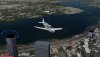
One word on my first impression: It looks very nice! The satellite image is huge and honestly I am not quite sure, how you ever want to fill it with autogen (manually). I checked the Openstreetmap data and it also is only very limited. Have you used so far what is available? it might be a good start. Another thing I would consider is to make the area a little smaller and fill this area completely with Autogen.


")